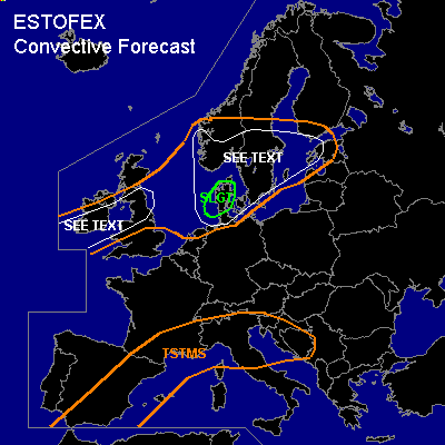

CONVECTIVE FORECAST
VALID 06Z FRI 22/10 - 06Z SAT 23/10 2004
ISSUED: 21/10 18:34Z
FORECASTER: GATZEN
There is a slight risk of severe thunderstorms forecast across Denmark
General thunderstorms are forecast across Great Britain, North Sea region, southern Scandinavia, Baltic Sea region
General thunderstorms are forecast across western and northern Mediterranean
SYNOPSIS
As upper long-wave trough over the Atlantic expands southwestward, very plain upper jet will dominate across Europe ... with a broad upper ridge over the Mediterranean and several vort-maxima affecting northern Europe.
DISCUSSION
...Great Britain, North Sea region, southern Scandinavia, Baltic Sea region
...
Two vort-maxima will affect the region on Friday. First rather strong vort-maximum should reach Denmark early on Friday. Current thinking is that a comma-cloud will develop in the unstable and weak-capped maritime airmass over the North Sea and widespread severe wind gusts as well as a few tornadoes should occur in the range of this convective line. During the day ... the vort-max is expected to reach the eastern Baltic Sea ... and thunderstorms should go on in the range of this feature. However ... decreasing instability is expected and organization/severe potential should decrease east of Denmark. Expect isolated severe wind gusts and probably a tornado. To the west ... second vort-max is expected to reach Great Britain during the afternoon. Maritime airmass with almost neutral lapse rates should destabilize and thunderstorms are expected due to synoptic forcing. Expect low LCL height, little CIN, and strong (up to more than 15 m/s 0-1km) low level vertical wind shear ... chance for tornadoes should be enhanced. Current thinking is that supercells will not form due to weak instability ... and chance for large hail seems to be low. However ... severe wind gusts and a few (brief) tornadoes are forecast. Overall threat seems to be too low to warrant a SLGT at this time.
#