CONVECTIVE FORECAST
VALID 06Z THU 21/10 - 06Z FRI 22/10 2004
ISSUED: 20/10 18:36Z
FORECASTER: GATZEN
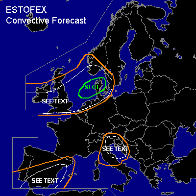
There is a slight risk of severe thunderstorms forecast across southern North Sea region
General thunderstorms are forecast across southern North Sea region, British Isles, southern Scandinavia
General thunderstorms are forecast across eastern Alps, northern Adriatic, Balkans
General thunderstorms are forecast across southern and western Iberian Peninsula
SYNOPSIS
Intense upper low W of the British Isles moves eastward reaching southern Scandinavia on Friday. To the south ... broad upper ridge will remain over the Mediterranean. At lower levels ... convectively mixed maritime airmass ATTM W of the British Isles will be advected into southern Scandinavia and northern Central Europe W of a cold front of intense cyclone centered over northern Scotland.
DISCUSSION
...Northwestern Europe
...
At the southern flank of northwestern European trough ... a intense jet streak/vort-max moves northeastward over the British Isles, southern North Sea region, and southern Scandinavia during the forecast period. At lower levels ... convectively mixed and slightly unstable maritime airmass is expected west of a cold front occlusion. In the range of the intense vort-max ... DCVA and some WAA are forecast, and synoptic forcing should be strong enough for thunderstorms in the weak capped airmass. Very strong vertical wind shear in the range of the jet streak (up to 40 m/s deep layer wind shear) should be adequate for organized convection ... and bow echoes and multicells as well as mesocyclones should be possible. Convective activity is expected to merge into one comma cloud late Thursday/ early Friday over the North Sea reaching southern Scandinavia later on. Severe wind gusts should be the main severe threat. A few tornadoes and isolated large hail are not ruled out though. Expected coverage/intensity of this comma cloud seems to warrant a SLGT ATTM. A downgrade will be needed on Thursday if model output/observations will not support actual scenario.
...Southern Iberian Peninsula
...
Moist and relatively warm maritime airmass is present over the southern Iberian Peninsula on Thursday. This airmass is characterized by weak CIN and nearly neutral lapse rates as indicated by latest soundings. On Thursday ... daytime heating should lead to instability reaching several 100 J/kg. At the eastern flank of eastern Atlantic long-wave trough ... a short-wave trough/vort-max is expected to cross the Iberian Peninsula on Thursday ... and synoptic forcing is expected. Thunderstorms should form and move ENE-ward. Organized thunderstorms are expected as deep layer wind shear will reach more than 20 m/s as indicated by latest GFS model output. It is not ruled out that a few mesocyclones will form, capable of producing isolated large hail and severe wind gusts ... and probably a brief tornado due to rather low LCL heights. However ... overall threat seems to be too low to warrant a SLGT. During the day ... upper vort-max is expected to move into western Mediterranean and convective activity should weaken.
...Eastern Alpine region to Adriatic
...
SE of propagating surface cold front ... relatively warm and unstable airmass will be present over the eastern Alps, northern Balkans, and Adriatic. Although synoptic forcing should be quite weak ... thunderstorms are expected to develop. Vertical wind shear will be quite low ... but deep layer shear seems to be strong enough to support a severe storm or two ... capable of producing large hail and severe wind gusts. Overall threat will be too low to warrant a SLGT.
#