
CONVECTIVE FORECAST
VALID 06Z MON 18/10 - 06Z TUE 19/10 2004
ISSUED: 17/10 23:21Z
FORECASTER: GROENEMEIJER
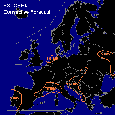
General thunderstorms are forecast across the southern North Sea, southwestern Iberia, Catalonia, southeastern France and northwestern Italy, the eastern Adriatic and the western and Northwestern balkans. Hungary and Slovakia and extreme southeastern Poland, the central Ukraine and southeastern Belarus.
SYNOPSIS
Monday at 06Z... south of a low-pressure area over southern Scandinavia a strong westerly mid/upper-level low is present over central and southern Europe. An intense trough over the central Ukraine is quickly moving eastward. Along a front ahead of the trough isolated thunderstorms are possible. Over Iberia the flow is more west-southwesterly. A warm front, behind which an unstable air-mass is present, is moving northeastward from the Atlantic and reaches Portugal during the afternoon. Near and behind the front, thunderstorms are expected. Warm advection is expected to increase over southeastern France and northwestern Italy as well, possibly leading to the formation of thunderstorms there as well. A bit downstream, a weak trough may aid a few thudnerstorms to form over the Adriatic area, Hungary, Slovakia and southeastern Poland.
DISCUSSION
#