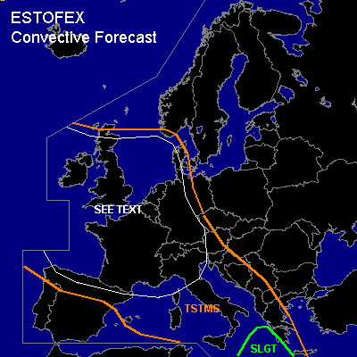

CONVECTIVE FORECAST
VALID 06Z FRI 15/10 - 06Z SAT 16/10 2004
ISSUED: 14/10 20:30Z
FORECASTER: GATZEN
There is a slight risk of severe thunderstorms forecast across southern and eastern Mediterranean
General thunderstorms are forecast across western and Central Europe, central Mediterranean
SYNOPSIS
Western European long-wave trough moves southeastward while its axis tilts counterclockwise. Around the periphery ... several strong vort-maxima affect western and central Europe as well as the northern Mediterranean. While cold maritime airmass spreads into northwestern Europe ... relatively warm and convectively mixed airmass is present from the North Sea to Central Europe and further to northern Iberian Peninsula and western Mediterranean. Over eastern and southern Mediterranean ... warm and unstable airmass will remain.
DISCUSSION
...Southern and eastern Mediterranean
...
Latest soundings indicate steep lapse rates above the boundary layer over the southern and eastern Mediterranean. Quite rich low-level moisture is also present creating instability ... that should reach CAPE up to 1000 J/kg locally. On Friday ... several weak vort-maxima should cross the region at the leading edge of the European long-wave trough ... and QG forcing due to WAA is expected. Thunderstorms should form and spread eastward. Increasing deep layer wind shear underneath the upper WSW-erly flow should be sufficient for organized convection, and multicells/supercells are expected ... capable of producing large hail and severe wind gusts. During the day ... a surface low is forecast to move NE-ward over the southern Mediterranean ... creating rather favorable low level wind shear in the range of its NErn sector for tornadic thunderstorms. A few tornadoes should be possible SW of Greece where low-level wind shear will be strongest and LCL height will be low.
...Western and Central Europe
...
Convectively mixed maritime airmass is expected in the range of the long-wave trough ... characterized by low CIN and rather high low-level CAPE values. As several vort-maxima will cross the region ... thunderstorms are expected to form over France, Alpine region, northern Italy, Benelux, Germany, Great Britain, and southern North Sea. Best chances for organized severe convection exists over northern Italy, where high SRH values should be present due to low-level SE-erly winds ... and isolated supercells capable of producing large hail and severe wind gusts as well a tornado or two are not ruled out. To the north ... deep vertical wind shear will be sufficient for isolated severe thunderstorms over southern France, southern and western Germany, and Alpine region. Isolated large hail, severe wind gusts and brief tornadoes are not ruled out. Further north ... vertical wind shear will be low. However ... low LCL heights may be favorable for spouts locally. Overall threat seems to be too low for a SLGT RISK. However ... later observations/soundings have to be awaited for an regional upgrade.
#