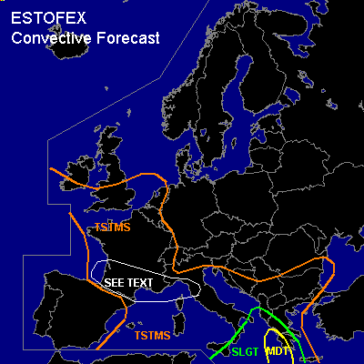

CONVECTIVE FORECAST
VALID 06Z THU 14/10 - 06Z FRI 15/10 2004
ISSUED: 13/10 20:39Z
FORECASTER: GATZEN
There is a moderate risk of severe thunderstorms forecast across SWrn Greece and surrounding Mediterranean
There is a slight risk of severe thunderstorms forecast across SErn central Mediterranean, southern Itlay and Sicily, western Greece
General thunderstorms are forecast across most of Mediterranean and southern Balkans
General thunderstorms are forecast across France, southern Great Britain, Benelux, southwestern North Sea, western Alpine region
SYNOPSIS
Broad upper trough is present over western Europe ... and upper jet ranges from southern Greenland to Iberian Peninsula where it splits into two branches at the southwestern flank of eastern European high. The southern branch is directed to the east, the northern branch surrounds the eastern European high. While the eastern high is filled with cold and dry low-level air, the central and eastern Mediterranean is dominated by warm and moist subtropical airmass. Relatively warm and unstable maritime airmass is present in the range of the upper trough over western Europe and western Mediterranean. On Thursday ... strong upper jet stretches southeastward at the western flank of western European trough. This momentum involves the trough axis to tilt counterclockwise.
DISCUSSION
...Eastern Mediterranean
...
On Wednesday ... upper short-wave trough moved across the central Mediterranean, where widespread thunderstorms formed. Associated vort-max will affect the eastern Mediterranean on Thursday reaching the Black Sea on Friday morning. In the range of this upper disturbance ... rather strong (20+ m/s 0-6 km) deep layer wind shear is forecast by latest numerical models that should be present over the Grecian area on Thursday. Latest LGIR Heraklion sounding shows well mixed airmass above the 850 hPa level and quite rich low-level moisture underneath the capping inversion ... and CAPE up to more than 1000 J/kg should be possible west and south of Greece where low-level airmass will be quite moist. GFS model output suggests even more than 1500 J/kg, but this seems to be too high and probably related to overestimated surface dewpoints over the Mediterranean of more than 20°C. However ... one observation over eastern Sicily actually shows 19°C dewpoint and later observations must be awaited to evaluate GFS moisture development. During Thursday ... convective activity/MCS should go on west and south of Greece propagating slowly eastward. Due to rather strong deep layer wind shear ... and also rather strong low-level wind shear near the Grecian coast with 10 m/s southeasterly surface winds ... organized convection will be likely. Expected mode will be one or two well developed MCS with embedded mesocyclones due to enhanced SRH values. If supercells will form ... tornadoes are expected SW of Greece where low LCL heights and rather strong low level SRH will be present. Some tornadoes may be strong. Large hail, severe wind gusts and intense rain/flash flooding should be possible as well. Convective activity should slowly shift northeastward while weakening over Greece due to decreasing low-level moisture and CAPE. Some non-severe thunderstorms may form over western Black Sea region later on.
...Western Europe
...
As upper jet streak stretches southeastward into France, a vort-max is expected to move into western Mediterranean and France at its leading edge. Over the western Mediterranean and France ... quite moist low-level airmass is forecast by latest GFS model output ... and should destabilize during the day due to insolation and upper cooling in the range of the propagating upper short-wave trough/vort-max. QG forcing is expected in the range of the upper vort-max due to DCVA and WAA and showers and thunderstorms should form. Although vertical wind shear will be rather low in the range of the vort-max ... GFS forecast indicates at least 15 m/s 0-6 km deep layer wind shear ... and some thunderstorms may organize. Best chances for isolated mesocyclones seems to exist over France during the afternoon and evening hours, when vertical wind shear should gradually increase in the range of the upper jet streak. If supercells will form, isolated large hail, severe wind gusts and intense rain are forecast, as well a brief tornado or two. Overall threat seems to be too low to warrant a categorical risk.
#