
CONVECTIVE FORECAST
VALID 06Z WED 13/10 - 06Z THU 14/10 2004
ISSUED: 13/10 00:40Z
FORECASTER: VAN DER VELDE
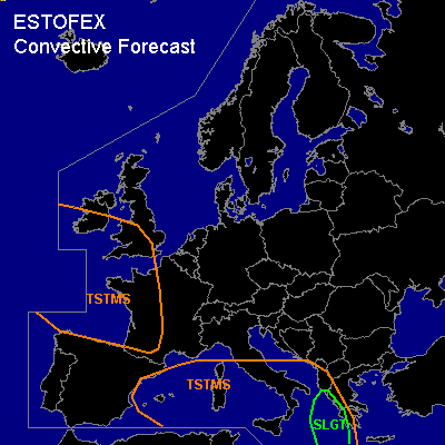
There is a slight risk of severe thunderstorms forecast across the Ionean Sea and coastal zones of Albania and Greece
General thunderstorms are forecast across the Mediterranean Sea area
General thunderstorms are forecast across western France and the British Isles
SYNOPSIS
A low pressure area south of Ireland advects cold, unstable air into Western Europe, with deep convection occurring at and behind the occlusion that enters France during the afternoon. A high pressure area over Russia pushes a cold front southward that will stagnate over the Balkan, meeting a tongue of high theta-e near Greece below an upper trough.
DISCUSSION
...the Ionean Sea and coastal zones of Albania and Greece...
The collocation of a tongue of high theta-e, strong low-level convergence and midlevel upward motions induced by the upper trough should provide ample lift for convection.
Several 100s to over 1000 J/kg CAPE should be available, along with significant SREH values (200-400 m2/s2) and moderate deep layer and low-level shear values, seem favorable for organised severe convection likely in the form of an MCS and a few supercells. Primarily the chance of severe gusts and large hail will be present, and a tornado or severe waterspout is also possible.
...western France...
At the rear side of the occlusion, strong CVA caused by the upper trough will enhance ascending motions, which may induce a line of thunderstorms given some 100s J/kg CAPE (GFS/NMM model). Part of the occlusion may be under the influence of moderate low-level shear, however CAPE/shear conditions look too marginal for organised severe weather.
#