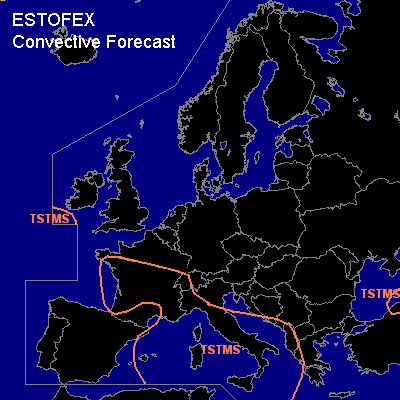
CONVECTIVE FORECAST
VALID 06Z TUE 12/10 - 06Z WED 13/10 2004
ISSUED: 12/10 06:12Z
FORECASTER: GROENEMEIJER
General thunderstorms are forecast across the central Mediterranean Sea, parts of the western Mediterranean Sea, Italy, central and southern France, the western Alps, the southern Adriatic Sea and its coasts, Albania, parts of Greece, and a part of northern Turkey.
SYNOPSIS
Tuesday at 06Z... a large high pressure area is located over southern Scandinavia at mid- and upper tropospheric levels. A deepening trough is located from near Ireland to western France. An intense trough is situated over Russia over the northwestern Ukraine into the northwestern Balkans, which is expected over the central Black Sea on Wednesday morning. A Wly to WSWly jet is located over the Mediterranean basin, colocated with a frontal zone in the low troposphere. The front is located from northern Algeria the southern Aegean Sea to southern Turkey. A weak shortwave trough is located over the Tyrrhenean Sea, which is expected to move eastward. Height falls are expected over the western Mediterranean, resulting in the gradual formation of a wide trough.
DISCUSSION
...central Mediterranean...
A neutrally to slightly unstably stratified air-mass is located north of the frontal zone over the western and central Mediterranean. Isolated thunderstorms can be expected in this air-mass. Storms will likely not be severe, given that the instability is low. Low LCL heights and weak low-level flow however indicate a chance of waterspouts.
Closer to the frontal zone, a numer of convective clusters will likely move eastward along the frontal zone where rising motions related to differential vorticity advection are forecast, over southern Italy, the Ionean Sea and western Greece. Deep-layer will be quite strong with 20-30 m/s shear between the surface and 6 km AGL. However, CAPE is expected to be quite low, so that the overall threat should be limited. Nevertheless, a few large hail or strong wind events could occur.
#