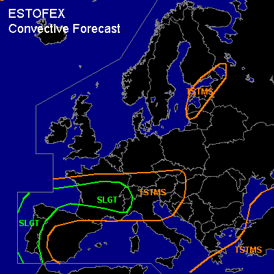

CONVECTIVE FORECAST - UPDATE
VALID 13Z FRI 08/10 - 06Z SAT 09/10 2004
ISSUED: 08/10 13:27Z
FORECASTER: GATZEN
There is a slight risk of severe thunderstorms forecast across western and northern Iberian Peninsula, Bay of Biscay, central France
General thunderstorms are forecast across see previous outlook
SYNOPSIS
Wide-stretched upper trough with an axis from northern Scandinavia to the Atlantic Ocean west of the Iberian Peninsula cuts off northwest of Portugal. During the cut-off process, a intense vort-max is expected to travel around the center affecting the western parts of the Iberian Peninsula and the Bay of Biscay. Intense cyclogenesis has set in and a well-developed surface low is expected to form just off the NWrn coast of Spain. Southerly to easterly winds to the east of this cyclone transport warm and unstable airmass originating from the western Mediterranean into France and the Bay of Biscay. Over Portugal ... warm maritime airmass will be present east of a cold front that should reach central Spain during the night.
DISCUSSION
...Western Iberian Peninsula, Bay of Biscay
...
Latest observations show that warm and moist airmass is present over the western Iberian Peninsula ... with dewpoints in the upper 10s ... creating rather strong low-level instability and CAPE in the order of several 100 J/kg. Just east of the approaching cold front ... strong vertical wind shear is present ... and high (100 m²/s²) 0-1km SRH is expected in the afternoon hours. Strong synoptic forcing in the range of the approaching vort-max and along the surface cold front should be likely, and thunderstorms that have already formed in the range of the warm front/cold front intersection just NW of the Iberian Peninsula should continue and move westward into the Bay of Biscay. Additional thunderstorms are expected to develop along the cold front over Portugal as convective inhibition will be weak and latest observations show quite energetic low-level airmass. Due to favorable vertical wind shear ... organized convection will likely develop ... and multicells and supercells are forecast ... capable of producing large hail, severe wind gusts and tornadoes. It is not ruled out that one or two tornadoes may be strong.
...France, western Alpine region
...
To the northwest of the cut-off low ... synoptic forcing will gradually decrease ... as cut-off process has set in leading to DAVA over parts of France and eastern Bay of Biscay. However ... well developed frontal boundary/warm front is present over the Bay of Biscay reaching eastward to the Alpine region. To the south ... instability has increased due to insolation over central and southern France ... and CAPE up to more than 1000 J/kg is expected. Showers and thunderstorms have already developed along the warm front and along a convergence line in the warm sector. Due to latest model output ... some WAA is forecast over France and western Alpine region ... and QG forcing should be strong enough for convective activity that should spread eastward. Although deep vertical wind shear will decrease somewhat ... quite strong low-level SRH values will be present in the warm sector over France and Alpine region ... and thunderstorms that develop should organize into multicells and supercells ... capable of producing severe winds and hail ... with the greatest chance over south-central France. Along the frontal boundary and the low-level convergence in the warm sector ... low-level moisture will be relatively high ... enhancing the tornado threat ... and a few tornadoes are not ruled out during the afternoon and evening hours. Overall threat seems to be high enough to warrant a SLGT ATTM.
#