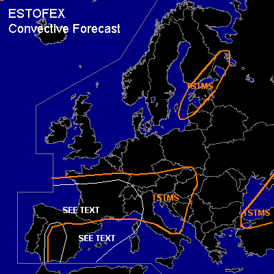

CONVECTIVE FORECAST
VALID 06Z FRI 08/10 - 06Z SAT 09/10 2004
ISSUED: 07/10 19:30Z
FORECASTER: GATZEN
General thunderstorms are forecast across western and northern Iberian Pensinsula, Bay of Biscay, northern Italy, most of France, Alpine region, Adriatic
General thunderstorms are forecast across eastern Baltic Sea region
General thunderstorms are forecast across the Black Sea and northern Turkey
SYNOPSIS
Enlarged and relatively sharp upper trough is present over Europe ... with an axis reaching from northern Scandinavia to the central North Sea and further to the Atlantic Ocean SW of Great Britain and W of the Iberian Peninsula. During Friday ... a cut-off process will create a intense closed upper low just northwest of the Iberian Peninsula ... as upper high south of Iceland moves eastward and connects to an upper high over central Mediterranean. At lower levels ... well defined frontal boundary will remain reaching from southern Poland to northern France and the northern Bay of Biscay. In association with a intense vort-max moving northward over western Iberian Peninsula ... strong cyclogenesis is expected west of the Bay of Biscay.
DISCUSSION
...Iberian Peninsula, Bay of Biscay, southern France, western Mediterranean
...
Focus of expected severe potential will be the forming cut-off NW of the Iberian Peninsula and associated strong upper flow over SWrn Europe. A strong vort-max is expected to travel around the upper trough and leads to cyclogenesis west of the Bay of Biscay ... where surface pressure should likely reach less than 990 hPa due to latest model output. To the east ... the well-defined frontal boundary should move northward over northern France and northern Bay of Biscay. South of the warm front, latest soundings show steep lapse rates above the boundary layer. Over the Mediterranean ... rich low-level moisture is present, creating relatively high CAPE in the order of 1500 J/kg. This airmass is expected to advect into southern France and eastern Spain on Friday ... where CAPE up to 1000 J/kg will be possible. However ... initiation is quite uncertain ATTM. In the range of the forming upper delta flow NE of the cut-off ... only weak developed vort-maxima are expected ... and QG forcing should be quite weak. Additionally ... quite cold boundary layer airmass will be present underneath a capping inversion, that may inhibit initiation over most of the area. Best chances seem to exist over France ... where a surface convergence in expected within the warm sector ... and low-level moisture will increase as indicated by latest model output. If thunderstorms will develop ... up to 20 m/s deep layer wind shear as well as 10 m/s 0-1km vertical wind shear will be sufficient for organized convection ... and supercells and/or multicells should develop ... capable of producing large hail and severe wind gusts. Best chances for tornadoes will exist over southern France ... where low-level moisture originating from the Mediterranean is expected. Allover coverage of thunderstorms is uncertain ATTM ... and a SLGT may be needed on Friday.
To the west ... rather strong DCVA is expected over western Iberian Peninsula and the Bay of Biscay in the range of an upper vort-max that should reach the Bay of Biscay on late Friday evening ... where thunderstorms are expected in the warm sector and in the range of the warm front. Rather strong deep vertical wind shear and CAPE in the order of several 100 J/kg should be sufficient for organized convection. Expect multicells and embedded mesocyclones due to enhanced SRH ... capable of producing large hail, severe wind gusts and a tornado or two. To the south ... cold front will move eastward over the Iberian Peninsula, where affected airmass should be quite stable during the night. A few thunderstorms may form ... but overall threat seems to be very low.
#