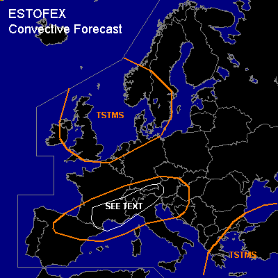

CONVECTIVE FORECAST
VALID 06Z THU 07/10 - 06Z FRI 08/10 2004
ISSUED: 06/10 16:58Z
FORECASTER: GATZEN
General thunderstorms are forecast across northern Iberian Peninsula, southern France, northern Italy, Alpine region
General thunderstorms are forecast across North Sea region, Great Britain, southern Scandinavia
General thunderstorms are forecast across Turkey, southern Black Sea, eastern Mediterranean, Greece
SYNOPSIS
Well developed upper trough present over NWrn Europe ... yielding a strong WSWerly flow from northern Iberian Peninsula to northwestern Russia. Underneath this upper jet ... a frontal boundary is present with warm and unstable airmass to the south over the Mediterranean ... southern France ... and Alpine region.
DISCUSSION
...Southern France to Alpine region
...
Seems that region with diurnal instability will be south of increasing deep layer wind shear over Central Europe. Soundings over the western Mediterranean shows quite steep lapse rates that should advect into France and northern Italy. At lower levels ... airmass seems to be relatively moist with dewpoints in the lower 10s C ... and GFS suggests CAPE in the range of 1000 J/kg. However ... CAPE should be significant lower over the area of interest ... and we expect around 300 to 500 J/kg during the day. Along the frontal boundary and to the south ... showers and thunderstorms should form due to diurnal heating. Given 15 m/s deep layer wind shear ... organized thunderstorms should be not very likely. However ... increasing low level wind shear as indicated by GFS model run ... seems to support low level helicity ... and in the afternoon/evening hours ... mesocyclones are not ruled out ... capable of producing a few tornadoes, isolated large hail and severe wind gusts. Overall threat seems to be low as QG forcing should be limited ... and we do not issue a SLGT risk at this time.
#