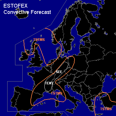
CONVECTIVE FORECAST
VALID 06Z WED 06/10 - 06Z THU 07/10 2004
ISSUED: 05/10 21:00Z
FORECASTER: GROENEMEIJER
General thunderstorms are forecast across The northwestern British Isles, southwestern Scandinavia parts of the Netehrlands and northwestern Germany and the North Sea as well as northeastern Spain, eastern France and parts of southern and central Germany and northwestern Italy and also across the Aegean Sea, eastern Greece and western and southern Turkey.
SYNOPSIS
Wednesday at 06Z... a southwesterly jet from western France to southern Scandinavia dominates the mid- and upper-level weather maps. Under the jet a waving frontal zone is present at lower tropospheric levels. Downstream, a ridge is located from the western Ukraine southwesterward into the central Mediterranean.
DISCUSSION
...southeastern France, Germany near the frontal zone...
Soundings and numerical models indicate a plume of high theta-e air is advected northward east of the frontal zone across eastern France and southern and central Germany.
This results in low amounts of latent instability along and just east of the frontal zone.
A few minor waves have been developing along the front over the last few days, and this may happen on Wednesday as well. Within the warm sector of a wave, backing surface winds may allow for some strong low level helcity veering to form. As thunderstorms are possible near the front and especially near wave discturbances, it is not ruled out that some storms develop mesocyclones as they ingest the low-level helicity. A small threat of strong wind gusts, some hail and perhaps a short-lived tornado will therefore exist. The overall threat however is too low for a risk category.
#