CONVECTIVE FORECAST
VALID 06Z TUE 05/10 - 06Z WED 06/10 2004
ISSUED: 05/10 09:26Z
FORECASTER: VAN DER VELDE
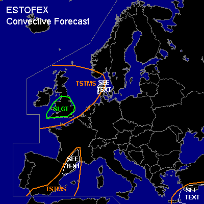
There is a slight risk of severe thunderstorms forecast across southern England
General thunderstorms are forecast across eastern Spain, southern France
General thunderstorms are forecast across southern Turkey, Crete
General thunderstorms are forecast across British Isles, Denmark
SYNOPSIS
An Atlantic low pressure system causes cold air to advect southwards behind a slow cold front that enters Western Europe. Unstable maritime polar conditions prevail over the British Isles, while warm air is advected northward ahead of the cold front over southern France into Germany. The jetstream causes deep-layer shear over 30 m/s and strong low level winds due to the tight pressure gradient causes also strong low-level shear over much of Western Europe. A cut-off low lingers over southern Turkey.
DISCUSSION
...southern England...
Deep layer shear over 30 m/s, 0-1 km shear over 12 m/s and low LCLs in combination with good low-level buoyancy indicated by GFS create favorable conditions for a few tornadoes (and severe gusts) to happen with the stronger convection. (possibly mini supercells - SREH slightly enhanced). This would especially be the case at the trough that is migrating over the area during the afternoon. Marginally large hail is also possible.
...southern France, northeastern Spain...
Ahead of the cold front, warm air is being advected into the region. Mon 12Z soundings, however, show very dry air in the source region (Nrn/Ern Spain, Mallorca), although SFLOCs indicate a small region where moisture apparently was sufficient for deep moist convection. GFS, NMM and ARPS models all show some few hundred J/kg CAPE into southern France by Tue afternoon, GFS has a strong sfc wind convergence area due to obstacle flow around the Pyrenees merging with frontal convergence zone, and 700 hPa UVMs/conv precip are indicated. However, expected convection seems to be high based (LFC >2500m) or elevated (K-index - best LI gives higher signal) and the cold front seems to become somewhat stationary. If storms manage to develop, moderate deep-layer shear, SREH and low level shear can organise them into a cluster, with marginal conditions for updraft rotation. This would mean a chance of marginally large hail and strong gusts, but at this time, the moisture situation seems too marginal to warrant a SLGT risk.
...Denmark...
In the late hours of the forecast period, good low level instability has spread over Nrn Denmark. Given the strong shear conditions below the jet and due to the sfc pressure gradients, convection may bring severe gusts and the possibility of an isolated tornado.
...Srn Turkey...
In the calm conditions below the upper low, instability is forecast to form as moist air is being advected into the area. If a sufficiently deep moist layer can be formed, waterspouts seem likely. However, 12Z Mon soundings were still very dry. GFS 12Z does yield significant convective precipitation which seems to be supporting the idea of sufficient moisture. Strong gusts are also likely given the possibility of entrainment into a storm of the still dry upper air.
#