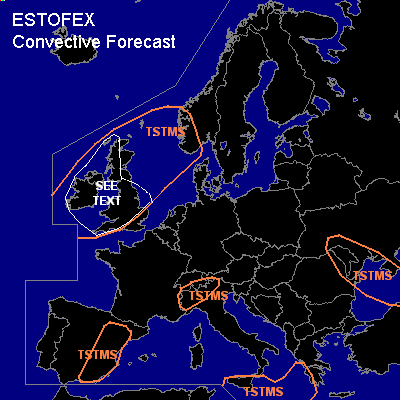

CONVECTIVE FORECAST
VALID 06Z MON 04/10 - 06Z TUE 05/10 2004
ISSUED: 03/10 21:20Z
FORECASTER: GROENEMEIJER
General thunderstorms are forecast across much of the British Isles, southwestern Norway, the nothern and central North Sea, eastern Spain, parts of the western and southern Alps, Sicily, the Ionean Sea and southwestern Greece, Moldova and the southwestern Ukraine and parts of the Black Sea.
SYNOPSIS
Monday at 06Z...west of a NE-SW oriented ridge from eastern Scandinavia to the western Meditarranean Sea, an intense trough is expected over northwestern Scotland and Ireland, that rapidly moves NEward over the North Sea and into Scandinavia, reaching central Sweden on Tuesday morning. Downstream... a trough is expected to be located over the Black Sea, extending over the Aegean Sea.
DISCUSSION
...British Isles...
Monday morning a cold front is expected over Wales and southwestern England. Strong differential cyclonic vorticity advection is expected over the front, which in combination with nearly neutral or slightly conditionally unstable conditions ahead of the front
possibly sustain a few convective lines. Given that low-level shear is strong /~20 m/s 0-1 km shear, there is potential for a few mesocyclones/ bows within these lines, that may produce a few tornadoes as well as severe wind gusts. The convective lines are expected to move eastward across Wales and parts of England during the morning and early afternoon hours and then move over the North Sea.
Postfrontal convection is expected to affect Irland and western Great Britain during the afternoon, evening, and overnight in coastal areas. This convection has the potential to cause strong to severe wind gusts.
#