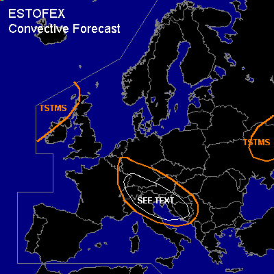

CONVECTIVE FORECAST
VALID 06Z FRI 01/10 - 06Z SAT 02/10 2004
ISSUED: 30/09 17:13Z
FORECASTER: GATZEN
General thunderstorms are forecast across southern Germany, eastern France, Alpine region, Adriatic, northern Italy, northern Balkans, NWrn British Isles, central Ukraine
SYNOPSIS
Intense trough has formed over the northeastern Atlantic, and a strong upper current is directed towards western Europe, where a well-defined delta will be present at the western flank of Scandinavian high. With the southern branch of the upper flow, a weak developed upper trough will move east over the Alpine region. Over eastern Europe, another trough is present.
DISCUSSION
...Alpine region, southern Germany, Adriatic and northwestern Balkans
...
On Friday ... upper trough will cross central and southern Germany. In the range of this trough ... relatively steep lapse rates are present above the 800 hPa level. In combination with quite rich low-level moisture ... CAPE of several hundred J/kg is possible as indicated by latest 03743 Larkhill sounding. On Friday ... model output suggests that moist airmass will be present over southern Germany ... and CAPE may reach more than 100 J/kg due to diurnal heating, as well as south of the Alps ... where relatively unstable airmass is also present as indicated by latest ascends. Showers and thunderstorms are expected. South of the upper trough ... increasing deep layer wind shear is expected over the Alpine region ... where more than 20 m/s 0-6km vertical wind shear is expected. Showers and thunderstorms may be organized and isolated mesocyclones are not ruled out capable of producing isolated large hail. As LCL height are quite low ... and low level vertical wind shear may be favorable north of the Alps and in the Adriatic ... the chance of tornadoes is enhanced ... and a few brief tornadoes are forecast.
#