CONVECTIVE FORECAST
VALID 06Z TUE 28/09 - 06Z WED 29/09 2004
ISSUED: 27/09 23:41Z
FORECASTER: VAN DER VELDE
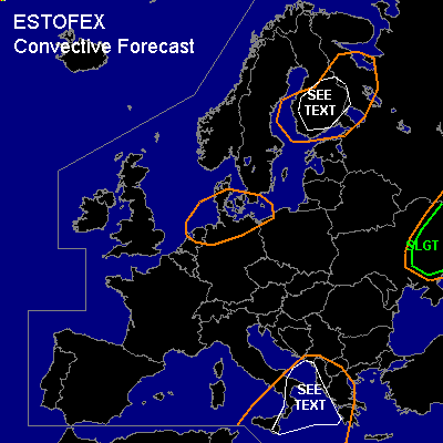
There is a slight risk of severe thunderstorms forecast across eastern Ukraine
General thunderstorms are forecast across central parts of the Mediterranean Sea, southern Italy, Greece, Albania
General thunderstorms are forecast across The Netherlands, northern Germany and Denmark
General thunderstorms are forecast across southern/central Finland and surrounding areas
SYNOPSIS
High pressure dominates southwestern Europe with quiescent conditions, while low pressure systems affect much of northern Europe. In the upper air, an area of low 500 hPa heights lingers over Srn/SErn Europe and is broadly indicating unstable air in its core and at its east flank, where high theta-e air is advected northwards, and also collocated with the subtropical jetstream. A shorter wavelength upper trough will activate a cold front by CVA, that will affect northern Germany and surrounding areas during the night Tue-Wed. High low-level shear conditions may occur ahead of the cold front, outside the unstable air.
DISCUSSION
...eastern Ukraine...
Unstable air will be present according to GFS 12Z, in the order of a few hundred J/kg CAPE. Mon 12Z soundings verified CAPE already being present and high theta-e air is being advected into the region. Convection will likely form at the theta-e wave that was situated over SW Ukraine Mon evening. Given the expected moderate/strong deep layer shear, enhanced SREH (>100 m2/s2 by GFS), and LFCs over 2 km but still enhanced low level instability, the primary risk seems to be marginally large hail and marginally severe gusts. Most forcing is forecast over the wave head in northern parts of the area.
...Finland...
As the core of the low with slightly unstable air moves over Finland on Tuesday afternoon, relatively quiescent conditions and low LFC height forecast to be less that 600m may support a few waterspouts over the lakes, that may move ashore and cause minor damage.
...coastal areas of Srn Italy, Greece and Albany...
Shallow low pressure with calm winds, unstably stratified air and steep boundary layer lapse rates over the warm coastal waters, together with the triggering influence of the jet (left exit) may result in a few waterspouts, especially during Tue/Wed morning when the difference between sea water temperature and air temperature is largest.
#