CONVECTIVE FORECAST
VALID 06Z TUE 21/09 - 06Z WED 22/09 2004
ISSUED: 21/09 00:42Z
FORECASTER: VAN DER VELDE
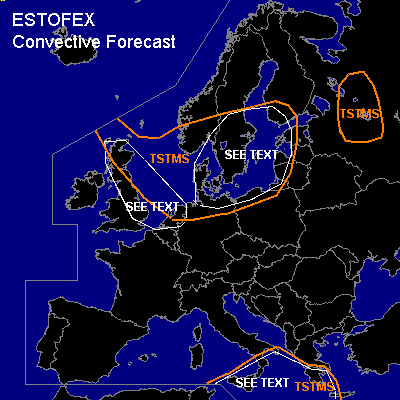
General thunderstorms are forecast across North Sea, Baltic Sea, and all bordering countries.
General thunderstorms are forecast across western Russia
General thunderstorms are forecast across southern Italy and southern Greece
SYNOPSIS
A low pressure system over Scandinavia is the most dynamically active feature over Europe. High pressure is present over the Atlantic 45N/20W with a strong pressure gradient over the UK, northern central Europe, the Baltic states and southern Scandinavia, and the jet stream is strong particularly over the UK into central Europe. A shallow low keeps unstable conditions going over the Mediterranean near Greece.
DISCUSSION
...UK, The Netherlands...
CAPEs are expected to be rather low, but a few showers could be possible, as GFS indicates convective precipitation. Under influence of the strong shear regime (0-1 km > 25 kts, 0-6 km > 40-90 kts, 0-3km SREH amounting up to 200 m2/s2) these could acquire rotating updrafts and a potential for tornadoes, if not severe gusts. Some troughs enhanced by the jet stream could provide the focus for the development of the storms. However, instability seems to be very marginal for widespread storms.
...Southern Scandinavia and western Baltic states...
lower pressure gradients and low shear conditions in combination with a few hundred J/kg CAPE forecast by GFS 18Z, together with steep lapse rates especially over sea, are a typical situation for waterspouts. A few may develop over land and cause a minor and very localised risk. Over Denmark, where low level shear is greater, the risk of a damaging tornado may be greater.
...Sicily, Srn Italy and Srn Greece...
shallow low pressure area with weak winds, low shear conditions in combination with a few hundred J/kg CAPE forecast by GFS 18Z, together with fairly steep lapse rates over the Mediterranean sea, are a typical situation for waterspouts where convection is surface based (west of Crete). A few may develop over land and cause a minor and very localised risk. In addition, the presence of dry upper air over this area, forecast especially near Sicily, may enable strong downdrafts by the entrainment process, which may result in severe gusts at the ground.
#