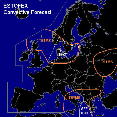

CONVECTIVE FORECAST
VALID 06Z MON 20/09 - 06Z TUE 21/09 2004
ISSUED: 20/09 00:00Z
FORECASTER: GROENEMEIJER
General thunderstorms are forecast across Scotland, much of the North Sea, the northern parts of the Netherlands, Germany, and Poland, southern Scandinavia and across southern Italy, the southwestern and southern Balkans and parts of Greece as well as across southern Belarus and much of the Ukraine.
SYNOPSIS
Monday at 06Z... a strong (70 m/s @ 300 hPa) westerly jet is located over the eastern Atlantic, having its exit region over the British Isles. The jet is expected to move eastward into northwestern Europe. In the lower troposphere a NE-SW oriented cold front is expected to move quickly southeastward to reach a line from the Baltic States to southern Germany to western France on Thursday morning. The front is followed by an intense mid/upper trough.
DISCUSSION
...North Sea area, southern Scandinavia...
Behind the cold front, upward motions are expected
ahead of the aformentioned postfrontal trough, resulting in destabilisation. NMM quite agressively develops about 800 J/kg of MUCAPE behind the cold front across Denmark and southern Sweden, while GFS has 50-100 J/kg of 30hPa MLCAPE.
It seems likely that a couple of linear convective systems develop behind the cold front affecting the indicated area during the late afternoon, evening and overnight. Given that low-level shear is strong, these will likely contain a few embedded mesocyclones, that pose a threat of severe wind gusts and possibly a few tornadoes. Small hail is possible as well.
...Ionean Sea...
To the east of a weak low pressure system, warm air is advected northward over the Ionean Sea into the Adriatic Basin. 50hPa-MLCAPE is generally expected to be in the 1000-2000 J/kg range. A few storms are expected to form as a result of rising motions. Within the indicated area, the storms have some opportunity to develop into supercells as deep-layer shear exceeds 15 m/s stronger there.
#