CONVECTIVE FORECAST
VALID 06Z SAT 18/09 - 06Z SUN 19/09 2004
ISSUED: 17/09 17:22Z
FORECASTER: GROENEMEIJER
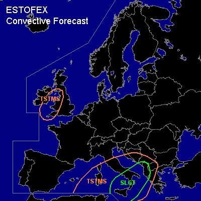
There is a slight risk of severe thunderstorms forecast across southern Italy and Albania
General thunderstorms are forecast across the central Mediterranean, the western Balkans and across parts of the British Isles
SYNOPSIS
Saturday at 06Z... a westerly flow is present over the northern half of Europe. A NE-SW oriented cold front is located over the British Isles and is expected to move eastward reaching a line from western Germany to central France to northwestern Spain tomorrow evening. A low-pressure area is located over the southern Tyrrhenean Sea.
DISCUSSION
...slight risk area...
Several MCS's are expected to form along a cold front extending southward from the aforementioned low pressure area.
Soundings and numerical models indicate about 1000-1500 J/kg and perhaps locally somewhat higher amounts of 50-hPA MLCAPE is present on the southern and eastern flanks of the low. Rising motions in combination with deep-layer (0-6 km) wind shear of 20 m/s are expected to sustain and allow for the development of a number of severe MCS's moving northeastward over the Mediterranean into southern Italy and across the Adriatic Sea into the western coast of the Balkans. Severe winds and large hail are expected to be the main threats. It is not completely ruled out that a weak tornado forms. Especially along the western coast of the Italian mainland low LCL heights are expected and a few waterspouts may well form.
#