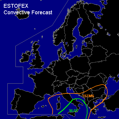

CONVECTIVE FORECAST
VALID 06Z FRI 17/09 - 06Z SAT 18/09 2004
ISSUED: 16/09 13:06Z
FORECASTER: GATZEN
There is a slight risk of severe thunderstorms forecast across Cetnral and southern Mediterranean
General thunderstorms are forecast across central Mediterranean, southern Balkans
SYNOPSIS
Sharp and amplified upper trough over Europe reaching from eastern Scandinavia to western Mediterranean moves eastward while its southern part slows down over southeastern Europe and the Mediterranean, where a cut off is expected on Friday morning. This cut-off will slowly move SSE-ward into southern Mediterranean. East of this cut-off ... warm and unstable airmass will remain over the central Mediterranean as cold front of surface pressure system will stall over the central Mediterranean.
DISCUSSION
...Central Mediterranean
...
Rather unstable airmass is present over the central and southern Mediterranean ... characterized by steep lapse rates above 900..800 hPa and rich low-level moisture underneath the capping inversion. Although boundary-layer moisture seems to be shallow especially over the southern parts of the forecast region ... CAPE50 should reach more than 1500 J/kg over the region on Friday. Deep vertical wind shear will decrease over the central Mediterranean east of the propagating cut-off ... with southwesterly winds aloft and easterly winds in the boundary layer ... but should be sufficient for organized convection. On Friday ... convection should continue in the range of the cut-off ... and nocturnal MCS may affect the region. New convection is expected along outflow-boundaries/cold front during the day and should spread southeastward into southern Mediterranean. Multicells will likely form as well as supercells due to enhanced SRH values ... especially over the southern parts of the risk area. Large hail, severe wind gusts and a few tornadoes are forecast. Best chances for tornadoes exist over southern Italy, where enhanced SRH is expected in the range of the cold front. During the night ... decreasing deep layer wind shear is forecast ... and chance for severe thunderstorms should decrease. Intense rain will become the main severe threat.
#