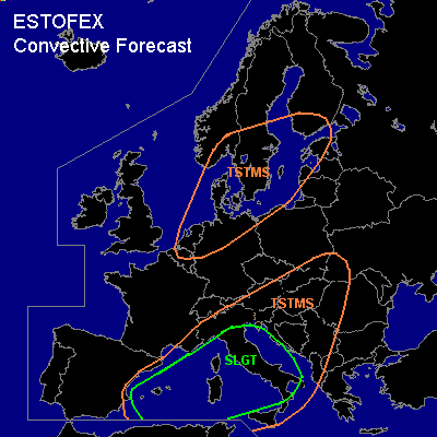

CONVECTIVE FORECAST
VALID 10Z WED 15/09 - 06Z THU 16/09 2004
ISSUED: 15/09 11:11Z
FORECASTER: GROENEMEIJER
There is a slight risk of severe thunderstorms forecast across the western and central Mediterranean including the Balearics, Corsica, Sardina, Sicily and parts of central and southern Italy.
General thunderstorms are forecast across the Netherlands, northern Germany, southern and southeastern Scandinavia and across the western and central mediterranean and the northwestern Balkans.
SYNOPSIS
Wednesday at 12Z... a longwave trough is located along a line from just west of Norway over western continental Europe to the Iberian peninsula. Three shortwave troughs are embedded within this trough. One over northwestern France, is expected to move southeastward and transform into a closed low over the southwestern Alps on Thursday morning. Two other troughs are located just west of southern Norway and over the eastern North Sea. These are expected to merge as they move eastward and reach the Baltic Sea on Thursday morning. Downstream of the longwave trough, mid and upper level flow is southwest. A cold front extends from the Baltic States to the Alps and the Spnish east coast. Ahead of the front a high theta-E plume extends across the western and central Mediterranean over eastern Europe.
DISCUSSION
...slight risk area...
Over the western and central Mediterranean, an elevated mixed layer is present topping a increasingly moist boundary layer. This results in high 50hPa-ML CAPE values of 1500 - 3000 J/kg. A cold front, located north of the Balearics at 12Z, is slowly moving southeastward across the western Mediterranean. Near the front, convective inhibition is rather low and scattered thunderstorms are occurring and will likely continue. High CAPE in combination with about 20-25 m/s 0-6 km wind shear should be more than adequate for storms to become severe. Despite relatively modest helicity values, supercells will be possible, that quickly merge into linears MCS's exhibiting bow-echo structures. Primary severe threats will be damaging winds and large or very large hail. As LCL heights are rather low, a few tornadoes cannot be ruled out either, although low-level shear should generally be rather low.
#