CONVECTIVE FORECAST
VALID 06Z TUE 14/09 - 06Z WED 15/09 2004
ISSUED: 14/09 01:13Z
FORECASTER: VAN DER VELDE
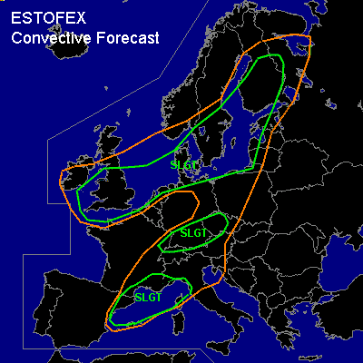
There is a slight risk of severe thunderstorms forecast across southern UK, Denmark, southern Sweden, Finland
There is a slight risk of severe thunderstorms forecast across southern Germany, northern Sitzerland
There is a slight risk of severe thunderstorms forecast across the northwest Mediterranean
SYNOPSIS
A very dynamic setup:
An autumn depression with strong pressure/height gradients migrates from Ireland to southern Scandinavia. In the airmass at/behind the cold front, CAPE will likely amount a few hundred J/kg, whereas moderate to strong deep layer shear is generated by the jetstream (80 kts @ 500 hPa, 120 kts @ 250 hPa Benelux area 00Z) over the cold front. The cold front, stretching from Srn France, Srn Germany, Poland into Finland at 12Z, and several troughs within the cold airmass will focus convective activity. Instability is primarily present over and near the relatively warm seas.
The northwestern Mediterranean Sea is particularly unstable with GFS forecasted CAPEs of >2000 J/kg possible. CVA of the approaching upper trough and sfc wind convergence in a shallow low pressure area provide triggers fro deep convection.
DISCUSSION
...southern UK, Denmark, southern Sweden, Finland...
UK: between 06-12Z a trough will move over this area. Some instability will be present, initially only over sea. GFS 18Z has forecast > 12 m/s 0-1 km shear and > 250 m2/s2 SREH over 0-3 km at 06Z. These provide enough support for cells with rotating updrafts and a chance of marginally large hail, damaging gusts in the already strong wind field, and a chance of a tornado or two.
Srn Scandinavia: with the jet over these areas, deep layer shear (0-6 km) ranges from 15-25 m/s and low level shears over 8 m/s can support some brief rotation in updrafts, with a chance of a tornado, marginally large hail, and severe gusts.
Finland: similar to the former areas, but with stronger shear and CAPE conditions forecast, therefore showers with rotating updrafts are more likely, with severe weather as described above.
In all areas, near throughs or the cold front, squall lines with bow segments may form posing a threat of damaging gusts.
...southern Germany, northern Sitzerland...
A plume of higher theta-w ahead of the cold front is forecast to be advected far enough northward from the Mediterranean to enhance instability over this area (GFS18 > 250 J/kg CAPE), where cold upper air, the jetstream and moderate low level shear come together. Orography may further enhance local shear conditions, not unlikely to a point favoring tornadogenesis. A bow echo squall line also appears to be a likely mode given the linear forcing, right entrance of the jet and shear conditions.
...the northwest Mediterranean...
Instability is the key component in this area rather than shear. This may give rise to large hail formation, severe downburst winds (delta theta-e > 15K). The shear is at most moderate, allowing organisation of cells, while the CVA and LL convergence provide lift. The LFC and CIN are forecast to be low, convective precip amounts by GFS 18Z provide significant indication that large amounts of rain can fall over Srn France. Low level buoyancy is forecast to be well enhanced, which would likely induce a few waterspouts in the generally calm synoptic conditions.
...NOTE...
Wherever reasonably deep convection manages to form in strong shear/marginal instability conditions, a SLGT would apply.
#