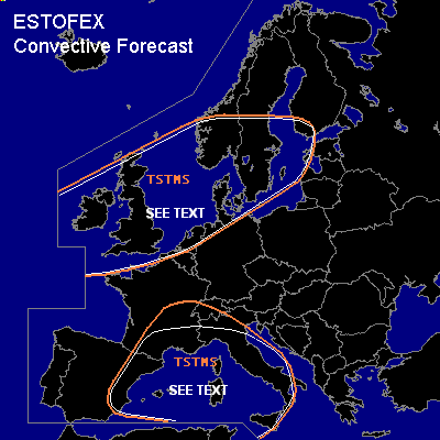
CONVECTIVE FORECAST
VALID 06Z MON 13/09 - 06Z TUE 14/09 2004
ISSUED: 12/09 23:04Z
FORECASTER: GROENEMEIJER
General thunderstorms are forecast across eastern Spain, southern France, northern Italy and the western Mediterranean, and across nortwestern Europe including the British Isles, the northwestern Benelux, northern Germany, and Southern Scandinavia
SYNOPSIS
Monday at 06 GMT/UTC... a longwave trough is expected to be located west of Ireland. An intense shortwave trough - initially over Ireland - will likely move eastward. A cold front is forecast to move eastward across Britain, the North Sea, and southern Scandinavia just ahead of the trough. Over the Channel, Low Countries and northern Germany the front will probably be slow-moving and one or two waves may develop. Over the western Mediterranean an elevated mixed layer is expected. Over the entire Mediterranean mid/upper level flow is forecast to be rather weak. Over eastern Europe, a weak to moderate zonal flow is forecast.
DISCUSSION
...western Mediterranean and surrounding areas...
A minor vorticity maximum is expected to move northeastward along the Spanish east coast. This may induce surface-based storms over the mountains of eastern Spain and over Catalonia, southeastern France and later across the western Alps. Shear is expected to remain rather low, limiting the severe threat. However, locally a few strong or marginally severe gusts and some large hail could occur. Over the Apennines a few surface-based storms will be possible as well, that will be capable of producing a few strong winds and some large hail as well. Elsewhere, across southern parts of the western Mediterranean scattered elevated convection is possible..
Overall threat is too small to warrant a risk category.
...northwestern Europe...
The NMM 12Z run develops a narrow band of CAPE to form ahead of the cold front as it moves eastward, which does not seem to be unreasonable given current temperature/dewpoint observations and latest radiosonde data. The CAPE will likely result in the formation of a convective band along the front or several line segments near the frontal zone.
The strongest upward motions and thereby the most frontal convective activity is expected across southern England, the southern North Sea, northern Benelux, northern Germany, southwestern Norway, Denmark and southern Sweden.
Given that low-level shear is expected to be quite high, it is possible that a few mesocyclones form, yielding a threat of a few isolated severe gusts and perhaps a few tornadoes. Allover threat is expected to remain quite low. In no particular area does the risk seem large enough at this moment to require a "slight risk" category.
Apart from convection along the front, postfrontal convection over the central and southern UK and Ireland will likely produce strong or severe gusts as well influenced by the strong lower tropospheric wind field.
#