CONVECTIVE FORECAST - UPDATE
VALID 11Z MON 06/09 - 06Z TUE 07/09 2004
ISSUED: 06/09 11:06Z
FORECASTER: GROENEMEIJER
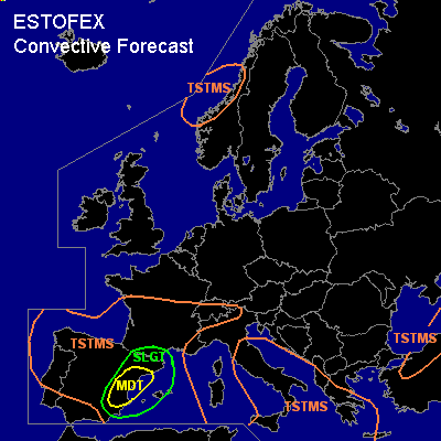
There is a moderate risk of severe thunderstorms forecast across eastern Spain
There is a slight risk of severe thunderstorms forecast across eastern Spain, extreme southeastern France and the western Mediterranean
General thunderstorms are forecast across much of Iberia, the western Mediterranean Sea, southern France, parts of Italy and the central Mediterranean Sea, the southwestern Balkans, western Greece, northern Turkey and a part of western Norway.
SYNOPSIS
refer to convective forecast
DISCUSSION
...eastern Spain...
Strong latent instability... 2000-3000 J/kg MLCAPE is exected to form during the afternoon hours across eastern Spain, as ample low level moisture has been advected inland under steep low and mid-level lapse rates. Somewhat weaker convective inhibition than yesterday suggests that storms may become rather widespread. Storms will most likely form along mountain ranges and then expand to the east coast and move offshore. As about 20 m/s deep-layer shear is forecast, it is likely that many storms will become supercells. These can produce damaging winds, very large hail and possibly a few tornadoes.
#