CONVECTIVE FORECAST
VALID 06Z MON 06/09 - 06Z TUE 07/09 2004
ISSUED: 05/09 16:19Z
FORECASTER: GROENEMEIJER
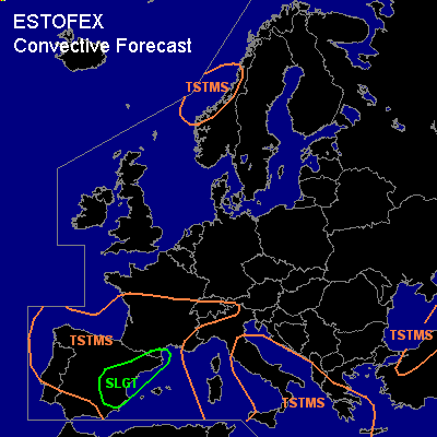
There is a slight risk of severe thunderstorms forecast across parts of eastern and central Spain and extreme southern France
General thunderstorms are forecast across much of Iberia, the western Mediterranean Sea, southern France, parts of Italy and the central Mediterranean Sea, the southwestern Balkans, western Greece, northern Turkey and a part of western Norway.
SYNOPSIS
Monday at 06Z... in the mid and upper troposhere, a strong westerly jet is located over Scandinavia. A high-pressure area is situated over central Europe. A low-pressure area is located over northern Portugal. A trough is located over the eastern Black Sea. It has a weak extension to the central Mediterranean. A cold front from Edinburgh to near Oslo to near Helsinki, is expected to move southward and reach a line from near Brimingham to Copenhagen to Moscow on Tuesday morning. An elevated mixed layer over Iberia extends northward to central France and is expected to progress northward to the latitude of Paris.
DISCUSSION
...slight risk area and western/central Iberia...
Over central and eastern Spain, the deep mixed layer that was present there over the past few days is expected to remain in place. The southerly flow is forecast to weaken, thereby slightly decreasing warm advection from the Sahara. Low-level temperatures are expected to drop somewhat as a result of this and because of increasing rising motions due to DCVA, reducing convective inhibition. As a significant amount of low-level moisture has been advected inland, quite high CAPE values of around 1500-2500 J/kg 50hPa-MLCAPE are expected locally. Deep-layer (0-6 km) shear around 15-22 m/s is forecast over southern and eastern Spain, and somewhat lower elsewhere. It is expected that storms develop Monday morning across Catalonia and southeastern France. These will likely merge into a large MCS. Additional convective development can be expected further south, most likely across the mountains of Aragón and Valéncia. Shear should be adequate for (embedded) supercells capable of producing large hail and severe winds as well as one or two tornadoes. Largest severe threat appears to be with the storms that develop further south as more CAPE is expected there. Storm coverage should be higher in the north of the risk area. Much less shear and CAPE are expected over north-central and northwestern Spain and Portugal, where storms should generally be non-severe.
#