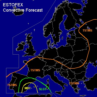

CONVECTIVE FORECAST
VALID 09Z FRI 03/09 - 06Z SAT 04/09 2004
ISSUED: 03/09 09:11Z
FORECASTER: GATZEN
There is a moderate risk of severe thunderstorms forecast across the southwestern Mediterranean
There is a slight risk of severe thunderstorms forecast across eastern Spain and western Mediterranean
General thunderstorms are forecast across southern and southern Central Europe, extremely eastern Europe
SYNOPSIS
Upper ridge builds over western and northern Europe ... while cut-off low over the eastern Baltic Sea moves SE-ward into western Ukraine. Over the Mediterranean ... upper ridge is present east of a cut-off low over western Iberian Peninsula. Warm and unstable airmass is present east of this cut-off low.
DISCUSSION
...Western Mediterranean
...
... this is a dangerous situation ...
East of the upper cut-off low over western Iberian Peninsula ... southwesterly upper flow transports mid-level steep lapse rates originating from the Sahara desert into western Mediterranean. Underneath the cap ... south of a surface low over Morocco and northern Algeria, easterly surface winds advect rich low-level moisture westward. Latest observations indicate surface dewpoints reaching 24°C over the western Mediterranean ... creating a very unstable airmass. 00Z Palma de Mallorca sounding already indicates more than 2000 J/kg CAPE. Today ... instability should remain while spreading westward into eastern Spain ... where up to 2000 J/kg CAPE are expected, although mid-level clouds will inhibit insolation. Over the affected region ... strong upper jet streak (30 m/s @ 500 hPa) is forecast by latest numerical models, and deep (0-6km) vertical wind shear is expected to increase during the afternoon/ evening to more than 30 m/s over extreme SWrn Mediterranean ... while low-level (0-1km) vertical wind shear should increase to more than 10 m/s south of Algerian surface low. SRH values will increase to more than 400 m²/s² in the lowest 3 km and more than 300 m²/s² in the lowest km as indicated by GFS model run. At the eastern flank of the cut-off low ... models suggest strong WAA and moderate DCVA in the afternoon/evening hours ... and QG upward forcing is expected ... that should weaken the cap over the western Mediterranean. Initiation is expected during the day over coastal regions/islands and along outflow-boundaries of old convection/MCS ATTM over NWrn Mediterranean. Thunderstorms will likely become supercells capable of producing large hail and severe wind gusts. Locally enhanced low-level wind shear ... quite low LCL heights and rather high SRH values will be sufficient for tornadic supercells. During the evening/night hours ... convection is expected to merge into one or two MCS ... capable of producing large hail and damaging wind gusts as well as intense precipitation leading to local flash flooding. However ... as SRH values will be very high ... embedded mesocyclones are likely ... and tornado potential is enhanced significantly due to low LCL heights and increasing low-level wind shear. Tornadoes are expected including a few strong ones. It is still uncertain that well-organized convection will manage to develop ... and QG forcing may be too weak to initiate widespread thunderstorms. However ... a MDT RISK is warrant given very favorable vertical wind shear and instability.
#