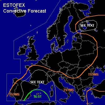

CONVECTIVE FORECAST - UPDATE
VALID 14Z THU 02/09 - 06Z FRI 03/09 2004
ISSUED: 02/09 14:18Z
FORECASTER: GATZEN
There is a slight risk of severe thunderstorms forecast across western Mediterranean
General thunderstorms are forecast across western and central Mediterranean, Iberian Pensinsula, France, southern Balkans, Black Sea region, extreme eastern Europe, western Russia, southeastern Finland
SYNOPSIS
While upper geopotential over Europe is increasing, upper short-wave trough over southern Scandinavia cuts of and moves eastward. West of the Iberian Peninsula ... another short-wave trough cuts of. Downstream ... warm and well-mixed airmass originating from the Sahara desert advects northward.
DISCUSSION
...Western Mediterranean ...
Latest Palma De Mallorca sounding shows rather weak CINV (-4.4 J/kg), while mid level lapse rates have decreased. However ... sufficient instability is present with CAPE of more than 1000 J/kg. During the next hours ... a vort-max indicated on WV images will enter the western Mediterranean ... and QG forcing is expected that should be strong enough for initiation over islands and coastal regions as well as along outflow boundaries. Deep vertical wind shear as indicated by latest soundings will remain quite high with more than 20 m/s 0-6 km vertical wind shear over parts of the western Mediterranean (GFS), and supercells are forecast capable of producing large hail and severe wind gusts. There is also a chance that tornadoes will form as locally enhanced SRH values and rather low LCL heights may create favorable conditions near islands, coastal regions, and outflow boundaries. During the evening/night hours ... increasing QG forcing is expected ... and coverage of thunderstorms should increase over the western Mediterranean. Strengthening low-level easterly winds and decreasing LCL heights should enhance tornado potential ... and a few tornadoes are expected. Convective activity should merge into one or two MCS during the night, moving eastward. Intense precipitation and flash flooding may be possible locally. As expected forcing is not too strong, we decide to keep the SLGT RISK category.
...Other areas...
See previous outlook.
#