CONVECTIVE FORECAST
VALID 06Z WED 01/09 - 06Z THU 02/09 2004
ISSUED: 31/08 19:57Z
FORECASTER: GROENEMEIJER
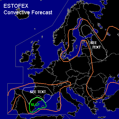
There is a slight risk of severe thunderstorms forecast across eastern Spain
General thunderstorms are forecast across southern France, parts of the Iberian peninsula and the western Meditarranean Sea as well as the southern Alps and across the Baltic Sea, eastern Europa and the eastern Balkans.
SYNOPSIS
Wednesday at 06Z... a cold air-mass is located over northwestern and central Europe in the vicinity of a low pressure system over southern Norway, from which a trough extends to Poland. There, the trough is expected to evolve into a new mid/upper level low pressure core. East of a cold front over Finland, western Russia, Belarus, a warm and unstable air-mass is advected northward. Upstream... a ridge moves eastward from the British Isles into continental Europe. A small shortwave over the Iberian peninsula is expected to move eastward. Another trough is approaching Europe and is expected along a line from the Irish Sea to just west of Portugal on Thursday morning.
DISCUSSION
...northern and eastern Spain......
Ahead of the trough over southwestern Iberia,
height/surface pressure falls are expected over the peninsula, which will increase the inland/upslope flow of moist air from the Mediterranean over northern and eastern parts, which will likely aid in the formation of scattered storms. An estimate based on current sounding observations and numerical models is that between 1000 and 2000 J/kg of MLCAPE should be come available in those areas.
As a southwesterly jet over the southeastern Iberian peninsula and the extreme western Mediterranean gradually strenghten, deep-layer (0-6 km) shear is expected to reach around 20 m/s in the southeast and around 10 m/s in the north. A few supercells may form in the southeast, whereas multicell clusters will probably dominate in the north. We will not issue a risk area for that region as chance of severe with multicells should be rather limited. Especially supercells will be capable of producing strong to severe wind gusts, and possibly some large hail although wet-bulb zero heights are rather high. A tornado cannot be ruled out either. Storms should diminish suring the late evening, except over northern parts, where elevated storms could move into southern France.
...indicated area over southern Finland, eastern Estonia and Latvia, western Russia, eastern Belarus...
...
Ahead of the cold front, isolated storms will likely form during the afternoon. Given the expexted moderately strong wind shear values, organised multicells will be likely, that may be capable of producing a few isolated large hail events and a few strong wind gusts. Overall threat seems to be too low to require a risk category.
#