CONVECTIVE FORECAST
VALID 06Z TUE 31/08 - 06Z WED 01/09 2004
ISSUED: 31/08 00:51Z
FORECASTER: VAN DER VELDE
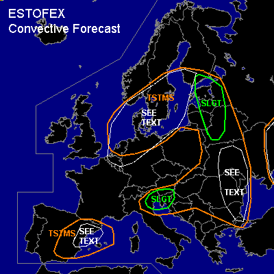
There is a slight risk of severe thunderstorms forecast across the eastern Baltic states, Belarus
There is a slight risk of severe thunderstorms forecast across northeastern Italy, Slovenia
General thunderstorms are forecast across the eastern Balkan, eastern Europe
General thunderstorms are forecast across southern Scandinavia, Netherlands, northern Germany
General thunderstorms are forecast across eastern Spain
SYNOPSIS
A depression with cold air aloft and rather steep pressure/height gradients migrates from the North Sea into southern Scandinavia, and is expected to fill up on Wednesday, while high pressure builds over central Europe. As cold air expands over Europe, theta-e gradients steepen at the cold front over Eastern Europe and the northern Mediterranean areas, which may cause enhanced frontal forcing. By Wednesday, moisture return slowly commences over Spain when a thermal low forms at approach of the next Atlantic front.
DISCUSSION
...Eastern Baltic states, Belarus...
GFS and NMM indicate MLCAPE in the order of 500 J/kg should be able to form ahead of the cold front. Over the slight risk area, the deep layer shear will be moderate... most shear will occur behind the cold front outside convective areas... Low level shear (up to 10 m/s over 0-1 km) is together with GFS 0-3 km MLCAPE over 100 J/kg and LCLs around 1 km sufficient for a few tornadoes. Gusts may be enhanced by midlevel dry air (delta theta-e > 10-15 deg) but may generally subsevere, except when a MCS manages to form which may develop bow echoes. Marginally large hail is likely to accompany some storms.
...northeastern Italy and Slovenia...
The advancing cold front causes enhanced ascending motions and convective precip according to GFS 12Z. The area is overspread by 0-6 km shear over 35 kts. Together with some instability and upslope flow ...enhancing SREH, some convection seems likely to develop which may include supercells. These pose the possibility of various types of severe weather: large hail, severe gusts and perhaps an isolated tornado.
...southern Scandinavia, Netherlands, northern Germany...
Unstable air with areas containing strong low level buoyancy circles around the core of the (upper) low. Spouts/tornadoes have occurred the previous day under similar circumstances. Especially in the low shear environment near the core of the low, convective clouds on wind shift lines are the main focus for spouts, which may then occur in groups.
...the eastern Balkan, eastern Europe...
GFS model indicates a good deal of low level buoyancy, e.g. in Romania. In conditions of almost absent wind(-shear), and in the parts of the area with very steep low level lapse rates, landspouts may occur in convergence zones. In addition, entrainment of dry midlevel air in storms may cause locally intense downburst winds. These conditions were already present in Bucharest Mon 12Z sounding. Flash flooding could occur due to slow movement of storms.
...eastern Spain...
Entrainment of dry midlevel air in storms may cause locally intense downburst winds.
...eastern Ukraine...
Mon 12Z soundings in the area indicate CAPEs and lapse rates strong enough for large hail. Possibility of a landspout exists in the low shear/steep lapse rate environment.
#