
CONVECTIVE FORECAST
VALID 06Z FRI 27/08 - 06Z SAT 28/08 2004
ISSUED: 26/08 16:45Z
FORECASTER: GATZEN
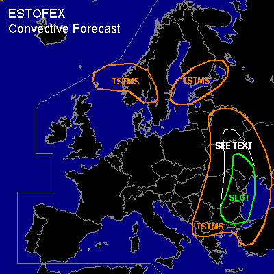
There is a slight risk of severe thunderstorms forecast across western Black Sea region
General thunderstorms are forecast across eastern Europe, parts of southern Scandinavia
SYNOPSIS
Upper short-wave trough ATTM over the Adriatic is forecast to cut off west of the Black Sea ... and QG sinking is expected to the NW ... Over NWrn Europe ... strong upper long-wave trough will expand SE-ward. At lower levels ... frontal boundary over eastern Europe is expected to move eastward, reaching the Black Sea at the end of the forecast period.
DISCUSSION
...Western Black Sea region
...
Seems that another round of severe convection will affect parts of eastern Europe ... as upper short-wave trough will cut of and dig into western Black Sea region. Models suggest that rather strong DCVA will be present SE of the upper low ... while upper jet streak (30+ m/s@300 hPa) will spread northward. At lower levels ... frontal boundary ATTM over the central Balkans is expected to move eastward reaching the Black Sea at the end of the forecast period. The airmass to the east is characterized by steep lapse rates above the boundary layer. Latest observations suggest that rich low-level moisture is present in the range of western Black Sea ... and it is expected that sufficient instability will form during Friday ... yielding CAPE values up to more than 1000 J/kg. Thunderstorms should go on/rebuild along the frontal boundary/outflow boundaries during the day ... and should likely become severe due to rather strong deep vertical wind shear. Supercells will be possible capable of producing large hail and damaging wind gusts. A tornado or two are not ruled out. During the afternoon/evening hours ... convective activity is expected to intensify as upper vort-max will reach the Black Sea ... and thunderstorms should merge into one or two MCS. Intense rain and local flash flooding will be possible ... and high winds are also expected. If embedded supercells will form, there is also a chance of isolated large hail as well as tornadoes due to increasing low-level wind shear.
...NWrn Ukraine, Wrn Belarus
...
Decreasing deep vertical wind shear ... and moderate instability should limit severe potential over this region. QG forcing is expected to decrease as upper short-wave trough cuts off ... and QG sinking sets in. However ... along the frontal boundary/outflow boundaries ... thunderstorms are expected in the morning hours that should be active during the day. Initially strong deep vertical wind shear and moderate low-level vertical wind shear should be sufficient for isolated severe thunderstorms ... capable of producing large hail, severe wind gusts and a tornado or two. Convective activity is expected to slow down during the day due to decreasing QG forcing.
#