
CONVECTIVE FORECAST - UPDATE
VALID 14Z THU 26/08 - 06Z FRI 27/08 2004
ISSUED: 26/08 14:10Z
FORECASTER: GATZEN
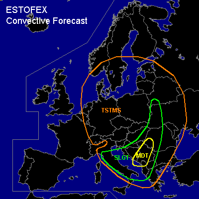
There is a moderate risk of severe thunderstorms forecast across central Italy, central Adriatic, and central Balkans
There is a slight risk of severe thunderstorms forecast across central and southern Italy, Adriatic, northern and western Balkans, western Ukraine, SWrn Belarus
General thunderstorms are forecast across central and eastern Europe, southern Scandinavia, NErn Mediterranean
SYNOPSIS
Upper long-wave trough present over Europe with an axis reaching from Germany into central Mediterranean. A strong short-wave trough/upper jet streak (45 m/s@300hPa) has reached northern Italy and propagates NE-ward ... and associated upper vort-max visible on latest WV images has entered northern Balkans. At lower levels ... cyclogenesis has set in over the Balkans along frontal boundary ATTM from central Adriatic to northern Balkans and further to the Romania/Hungarian boarder.
DISCUSSION
...Balkans, Adriatic, eastern Europe
...
Intense convection has formed in the range of the upper trough ... with a MCS over the northern Balkans and strong convective cells over Italy, the Adriatic, SWrn Ukraine, and the eastern Polish boarder. Warm airmass east of the frontal boundary is characterized by steep lapse rates ... and locally rich low-level moisture. Model output suggests CAPE up to 2000 J/kg ... and we expected that this values may be possible locally ... although no soundings are available that could confirm the model output. Best low-level moisture is located over the Adriatic and just along the frontal boundary. Storms that have formed along the frontal boundary should quickly become severe given large (25 m/s 0-6km) vertical wind shear ... and supercells are likely capable of producing very large hail, damaging wind gusts and intense rain. There is also a threat of tornadoes ... especially along the Adriatic and the frontal boundary, where low-level moisture will be rather rich. During the evening hours ... convective activity should spread into the central and southern Balkans as well as the western Ukraine and Belarus, where thunderstorms have already formed along the frontal boundary. Increasing low-level wind shear as indicated by latest model output and locally low LCL heights may be sufficient for a strong tornado or two. However ... main severe threat will be severe wind gusts over the central Balkans due to well-mixed boundary layer as well as local flash flooding due to very intense rain.
#