
CONVECTIVE FORECAST
VALID 06Z THU 26/08 - 06Z FRI 27/08 2004
ISSUED: 25/08 17:35Z
FORECASTER: GATZEN
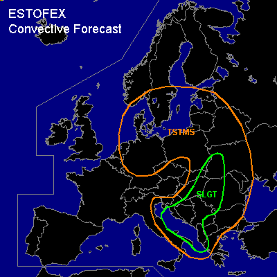
There is a slight risk of severe thunderstorms forecast across the Adriatic, central and northern Balkans, western Ukraine, southwestern Belarus
General thunderstorms are forecast across northern and central Germany, Benelux, southern Scandinavia, Baltic states, eastern Poland, western Belarus, western Ukraine, northern and central Balkans, eastern Italy
SYNOPSIS
Intense long-wave trough covers northwestern and central Europe. A vort-max ATTM over France is expected to cross the northern Mediterranean reaching northern Balkans at Friday, 00Z. At lower levels ... steep lapse rates over the southern and central Mediterranean are advected NE-ward into SErn Europe, while cold airmass spreads into the western Mediterranean in the wake of the upper trough.
DISCUSSION
...Eastern Europe
...
Downstream of propagating upper long-wave trough ... relatively warm airmass is present over eastern Europe east of a frontal boundary. Models suggest that a frontal wave will form along this boundary moving northward. To the east ... warm airmass is advected into western Belarus, western Ukraine, and Hungary. This airmass is characterized by rather steep lapse rates below 700 hPa and relatively poor boundary-layer moisture as indicated by latest ascends. Nonetheless, numerical models forecast large CAPE values on Thursday due to increasing low-level moisture. ATTM, we cannot confirm this large CAPE values ... however, it seems that low-level moisture and steep lapse rates aloft will be separated by the frontal boundary ... and we expect that CAPE will reach up to 1000 J/kg over southwestern Ukraine as indicated by NMM output. To the north and west ... CAPE should be lower due to poor lapse rates. This instability is coupled with rather strong vertical wind shear ... and models suggest more than 20 m/s deep layer wind shear over Hungary, Romania, and western Ukraine during the afternoon. In the range of the surface low ... low-level backing winds are forecast and 0-1km vertical wind shear is expected to increase to more than 10 m/s in the evening. During the day ... rather strong QG forcing is expected over the region due to WAA east of the frontal boundary/developing surface low and DCVA east of the propagating vort-max. Thunderstorms are forecast that will likely become severe given rather large vertical wind shear ... and supercells are expected capable of producing isolated large hail, damaging wind gusts and tornadoes. However ... thermodynamic profile of affected airmass is not clear ATTM ... especially the development of low-level buoyancy. Later observations have to confirm if this scenario materializes. Convective activity is expected to merge into a MCS later on ... and widespread severe wind gusts will be possible. We decide to issue a SLGT RISK ... however ... if widespread CAPE will build during Thursday ... an upgrade to MDT will be necessary.
...Adriatic...
Soundings indicate steep lapse rates over the Mediterranean that spread eastward into the southern and central Adriatic. Models suggest rather rich low-level moisture creating CAPE values up to 1000 J/kg. During the day ... cold front is expected to reach the central Adriatic ... and thunderstorms are expected along the cold front. Aloft ... weak vort-max will lead to DCVA and QG UVM is expected ... that should support initiation south of the cold front ... especially along the western coast of the Balkans. Vertical wind shear is expected to increase gradually to the north ... and thunderstorms that form may be severe capable of producing large hail and severe wind gusts. Tornadoes are not ruled out as low-level airmass is expected to be moist underneath the capping inversion and LCL heights will be rather low locally.
#