
CONVECTIVE FORECAST
VALID 06Z WED 25/08 - 06Z THU 26/08 2004
ISSUED: 24/08 21:39Z
FORECASTER: GROENEMEIJER
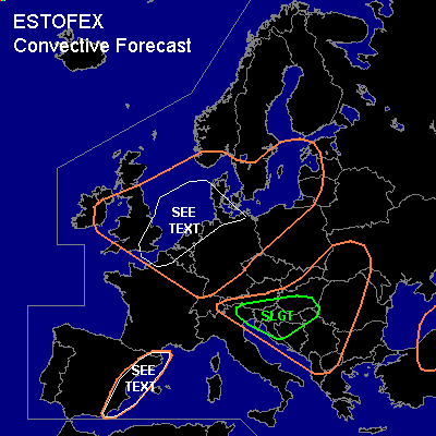
There is a slight risk of severe thunderstorms forecast across extreme southern Austria, northeastern Italy, Slovenia, southern Hungary, much of Croatia, northern Serbia, and northern Bosnia and Herzegovina.
General thunderstorms are forecast across parts of the British Isles, the Low Countries, northern France, much of Germany, extreme southern Scandinavia, the western Baltic States, northwestern Poland and across the southeastern Alps, the northern and western Balkans and the western Ukraine and also across eastern Spain.
SYNOPSIS
Wednesday at 06Z... a slightly cyclonic westerly jet is forecast over western Europe that has its axis over central France and along the Alps. Gradually it is expected to becime more NW-SE oriented. A shortwave over northern France is expected across Poland on Thursday morning. Another shortwave trough that is initially located over southwestern Ireland is expected over the western Alps by then. A well-mixed nearly neutral air-mass is expected over much of western, central and northern Europe.
DISCUSSION
...slight risk area...
Under the aforementioned jet, about 20 m/s of deep-layer shear should be present. Although lapse rates will likely not be very steep, between 500 and 1000 J/kg MLCAPE 50 should be able to form over the area, especially as mid-level temperatures drop during the evening hours. Scattered storms are expected to form over the area by late afternoon and during the evening hours. The amount of shear should be adequate for updraft rotation. the storms will have a risk of producing some large hail, strong to severe winds and perhaps a tornado or two.
...eastern Spain...
Inland and upslope flow will likely aid in the formation of a few scattered storms across eastern Spain. Inverted-V type profiles suggest a few strong downbursts are possible with those storms. Storm coverage is expected to remain low, so that a risk category is not warranted.
...cnetral, southern UK, eastern Ireland, Low Countries, northern France, Denmark, NWrn Germany...
Low LCL heights suggest scattered covection could be accompanied by a couple of waterspouts/weak tornadoes, most likely along convergence lines over water surfaces.
#