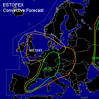

CONVECTIVE FORECAST
VALID 06Z TUE 24/08 - 06Z WED 25/08 2004
ISSUED: 24/08 01:39Z
FORECASTER: VAN DER VELDE
There is a slight risk of severe thunderstorms forecast across Ern Spain, SErn France, Nrn Italy, parts of Germany and the Alps, Czech Republic
There is a slight risk of severe thunderstorms forecast across Ern Ukraine, Russia
General thunderstorms are forecast across UK, Benelux, Denmark
SYNOPSIS
A 500 hPa wave is forecast to swing through Western Europe. It initiates a wave in the cold front that runs through the SLGT area. The wave will develop over NErn France and Germany. Upper air winds are rather strong, as well as the winds and directional shear at lower levels, setting up a favorable kinematic environment for severe storms over a wide area. A barotropic low filled with unstably stratified air will linger over the UK, Benelux, North Sea and Denmark.
DISCUSSION
...Eastern Spain, Southeastern France, Northern Italy...
A progressing cold front with a steep horizontal theta-w drop pushes into unstable air. CAPE should range from 500-2000 J/kg according to GFS 12Z, and deep layer shear (>20 m/s 0-6 km) and SREH (around 150-250 m2/s2 0-3 km) are plentiful over a wide area to support supercell storms, either isolated or embedded in MCSses. Due to the strong low-level shear (15 m/s over 0-2 km), bow echoes accompanied by severe winds are likely during the lifetime of an MCS, and tornadoes can certainly supported by this amount of shear.
Forecast upslope winds in the BL may help breaking the cap in Ern Spain and Nrn Italy. This may result in an isolated supercell or perhaps a cluster of storms in these places, that may evolve into an MCS supported by the UVMs of the frontal circulation as evening falls. However, models except ARPS are reluctant in giving precip in these areas today, especially Spain, so the cap may just hold.
In all areas, once storms form, there is a risk of large hail, severe gusts, and where LCLs are low (SErn France), an increased likelyhood of a tornado.
...Germany, Switzerland, Austria, Czech Republic...
These areas are different from the above areas in the following sense. A lower range of CAPE (few hundred J/kg), better low level buoyancies, and lower LCLs. A baroclinic wave provides very strong forcing. GFS and NMM forecast the best CAPE over NWrn Germany. This is where shear is forecast to be weakest. Conditions there seem to favor spout (vort stretching) type tornadoes, whereas good shear conditions towards the south support mesocyclonic (vort tilting) type tornadoes. Instability in southern parts seem marginal, probably due to lack of moisture, while good lapse rates seem in place (Mon 12/18Z soundings). Best of both worlds seem to be along a strip through central Germany. Apart from favorable tornado conditions, a squall line seems a likely mode, with the chance of bowing segments (severe gusts) where shear is best. Large hail can also be expected with some storms.
...Ern Ukraine, Russia...
Previous day's soundings in the area indicate MLCAPEs above 900 J/kg. Although the dynamic/kinematic setup is mostly weak along the area, convergence within the theta-e ridge will cause storms with a primary potential of large hail and severe gusts (dry midlevel air entrainment).
..."see text" area...
A barotropic low filled with unstably stratified air will linger over the UK, Benelux, North Sea, northern Germany and Denmark and cause showers and thunderstorms. Weak flow will cause slow movement of storms, which may cause local flooding. These conditions are also favorable for spouts, especially near convergence lines in calm conditions. These may occasionally do damage on a very local scale. The favorable spout conditions last very well into Wednesday morning in coastal areas.
#