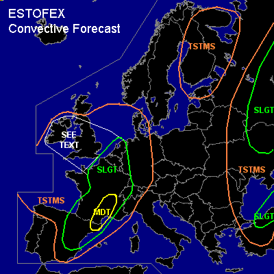

CONVECTIVE FORECAST - UPDATE
VALID 16Z MON 23/08 - 06Z TUE 24/08 2004
ISSUED: 23/08 16:22Z
FORECASTER: GROENEMEIJER
There is a moderate risk of severe thunderstorms forecast across The Lower Rhone Valley, Languedoc, Roussillon, and northeastern Catalonia.
There is a slight risk of severe thunderstorms forecast across northern, central, eastern and southern France, the Benelux countries and western Germany, western Switzerland, northeastern Spain
There is a slight risk of severe thunderstorms forecast across northern Turkey
There is a slight risk of severe thunderstorms forecast across the northeastern Ukraine and parts of Russia
SYNOPSIS
refer to conv. forecast
DISCUSSION
...mdt risk region...
Between 1000 and 2000 J/kg MLCAPE has likely formed in the region. Convective activity over the region is expected to increase during the evening hours. The convective modes are expected to include bow-echoes and supercells capabale of producing damaging winds and large hail. Strongly veering low-level winds and around 20 m/s deep-layer shear should be adequate for the formation of strong low-level mesocyclones that may cause tornadoes in the area.
...Benelux...
Scattered convection is developing. Given that low-level flow is highly helical, especially over the Netherlands and parts of Belgium, and strong deep-layer shear is expected a few supercells will likely form in addition to the one near Amsterdam around 16Z, that may cause large hail and severe winds.
#