CONVECTIVE FORECAST
VALID 06Z MON 23/08 - 06Z TUE 24/08 2004
ISSUED: 22/08 22:12Z
FORECASTER: GROENEMEIJER
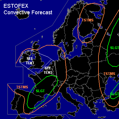
There is a slight risk of severe thunderstorms forecast across central, eastern and southern France, western Switzerland, northeastern Spain
There is a slight risk of severe thunderstorms forecast across northern Turkey
There is a slight risk of severe thunderstorms forecast across the northeastern Ukraine, across parts of Russia
General thunderstorms are forecast across much of western Europe, much of extreme eastern Europe adn across eastern Scandinavia
SYNOPSIS
Monday at 06Z... a trough is located west of Ireland with a more pronounced shortwave on its its southwestern flank expected over the Bay of Biscay on Tuesday morning. Over central Europe a broad ridge is located. A trough over eastern Scandinavia moves eastward reaching northwestern Russia on Tuesday morning. An intense trough over the eastern Balkans moves eastward to the north-central Black Sea area.
DISCUSSION
...France, Switzerland, Spain...
An elevated mixed layer of the Spanish plateau is expected to overspread France southeast of a line from Luxembourg to Bordeaux. Models indicate that a few 100's of J/kg MLCAPE can be expected across this area. Weak upward motions related to thermal advection will likely allow for the formation of scattered storms across the aformentioned area as well as across lower Switzerland. As deep-layer shear is expected to be in around 20 m/s supercells can be expected capable of producing large hail and strong winds. Storm coverage should increase during the evening hours and one or two big MCS's may form over France.
Further south... over Spain more scattered convective development is expected. However, rather high CAPE values may be realised as low level moisture of the Mediterranean is advected inland, most likely across the Ebro Valley. Scattered storms are expected here as well, that will likely diminish in coverage during the late evening. The storms can produce large hail and strong winds. Some tornado threat is expected across northeastern Spain, the Rhone Valley and the Languedoc where low-level shear is expected to be rather strong (10-15 m/s 0-1 km shear).
...northern Turkey...
Ahead of the trough moving into the Black Sea area rising motions are expected to aid the formation of scattered to widspread convective storms across the Black Sea area and northern Turkey. Deep-layer shear around 20 m/s will likely allow dor the formation of supercells and/or bow echoes that may produce strong/severe winds and large hail.
...Russia, eastern Ukraine...
Along or just ahead of a cold front initially approximately along a line from Yaroslavl to Moscow to Odessa, scattered storms are expected to develop during the afternoon hours. Along the part of the front included in the slight risk area, shear should be strong enough to allow for organised severe storms, possibly including supercells. Isolated large hail and severe winds can be expected.
...Benelux, northern France...
Some CAPE is expected to form in thsi area during the afternoon. Models predict no significant forcing across this area within this time frame, so that deep moist convection may be completely supressed. However, if a few storms form, shear will be adequate for updraft rotation. Large hail and strong/severe winds will then be possible.
...UK, Ireland...
Scattered storms are expected in the air-mass over the central/southern UK and Ireland.
Low LCL heights are forecast which may help a few waterspouts/weak tornadoes to form.
#