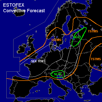

CONVECTIVE FORECAST
VALID 06Z FRI 20/08 - 06Z SAT 21/08 2004
ISSUED: 19/08 18:12Z
FORECASTER: GATZEN
There is a slight risk of severe thunderstorms forecast across Baltic states, western Russia
There is a slight risk of severe thunderstorms forecast across northern Itlay, northern Balkans
General thunderstorms are forecast across western, central and eastern Europe, southern Scandinavia, northeastern Europe, western Ukraine
SYNOPSIS
Intense upper long-wave trough present over western Europe ... slowly expanding eastward. At its southeastern flank ... strong upper jet stretches from Spain to eastern Scandinavia. To the NW, several vort-maxima are forecast. At lower levels ... warm and unstable airmass is present SE of the frontal zone underneath the jet ... that is advected into eastern and northeastern Europe ... while cold airmass spreads into western Mediterranean and Central Europe. In the range of the trough ... convectively mixed airmass is expected over France, Benelux, and Germany.
DISCUSSION
...Baltic states, western Russia
...
Frontal wave ATTM over the Alps is expected to move NE-ward reaching the Baltic Sea tomorrow ... where associated MCS/stratiform rain is expected. To the east ... WAA is forecast over the Baltic states/western Russia. Latest observations/soundings show that this airmass is characterized by steep lapse rates over Poland and rather moist boundary layer over the Baltic states. Expect that sufficient instability will form during the day over the Baltic states as upper steep lapse rates spread northward ... and CAPE up to 1000 J/kg is forecast. During the day ... forcing is expected along the frontal boundary/outflow boundary due to low-level convergence and WAA ... and thunderstorms should develop over the Baltic states. Underneath the upper jet ... rather strong deep layer wind shear should be sufficient for organized convection. Supercells are expected capable of producing large hail, damaging wind gusts and a few tornadoes, especially where outflow-boundaries may create low LCL heights and favorable low level wind shear.
...Northern Italy, northern Balkans
...
Western European trough expands southward ... and upper strong jet is expected over the Alps on Friday. While cold airmass spreads into western Mediterranean ... warm and unstable airmass is expected to remain over northern Italy and northern Balkans. Latest soundings show that steep lapse rates are still present over northwestern Italy ... while moist airmass with dewpoints around 17 C are analyzed. Expect that sufficient instability will develop during the day ... and thunderstorms should likely form as CIN will be weak. Strong deep layer wind shear will be adequate for mesocyclones ... and large hail, severe wind gusts and a tornado or two are forecast. Convective activity should spread eastward during the evening/night hours into the Balkans. Increasing QG forcing due to upper vort-max may support the formation of a MCS. Large hail and severe winds should be the main threat.
...Southern Great Britain, northern France, Benelux, northern Germany, southern Denmark, eastern Poland
...
In the range of the upper trough ... convectively mixed airmass is expected ... that should destabilize due to diurnal heating ... with MLCAPE50 in the order of several 100 J/kg. During the day ... strong vort-max is expected over the region ... that should lead to sufficient DCVA and linear forcing along its axis. CAA is also forecast to influence the area in the evening. However ... QG forcing should be quite strong in the range of the trough axis ... and showers/thunderstorms are expected capable of producing severe wind gusts and small hail due to rather strong low-level wind shear and moderate deep-layer wind shear. There will be also a chance of mesocyclones given enhanced SRH values ... capable of producing isolated large hail and a brief tornado or two. Increasing CAA should lead to stabilization during the evening hours.
...Eastern Europe
...
Along the frontal boundary ... severe potential will be limited over eastern Europe ... as low-level CAA has begun to spread eastward... however ... it is not ruled out that isolated mesocyclones will form due to locally enhanced SRH. Large hail should be the main threat.
#