CONVECTIVE FORECAST - UPDATE
VALID 14Z WED 18/08 - 06Z THU 19/08 2004
ISSUED: 18/08 14:41Z
FORECASTER: GROENEMEIJER
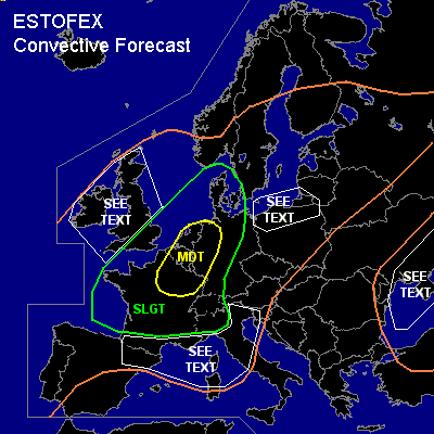
There is a moderate risk of severe thunderstorms forecast across northern France, northwestern Germany and the Benelux countries
There is a slight risk of severe thunderstorms forecast across an area surrounding the moderate risk area including the southeastern UK, Denmark, a large part of Germany, much of France and Switzerland and northwestern Italy
General thunderstorms are forecast across much of western Europe, central Europe, the Baltic States, southern Scndinavia, and a part of Russia as well as the area around the Black Sea.
SYNOPSIS
refer to convective forecast
DISCUSSION
...France, Benelux, western Germany...
12Z soundings show that 500 - 1000 J/kg of MLCAPE50 has formed over the Benelux, northern France. Thunderstorms have initiated along a line from near Paris to near Bordeaux. Additional convective development over northern and central France and Belgium is underway. 20-30 m/s deep-layer (0-6 km) shear over the area should be more than adequate for storms to develop into supercells capable of producing severe winds, large hail and isolated tornadoes. The convection will likely spread northeastward into northeastern France, western Germany and the Benelux countries. A more pronounced severe wind threat
is expected to develop gradually as storms cluster into a bowing linear MCSs.
#