CONVECTIVE FORECAST
VALID 06Z TUE 17/08 - 06Z WED 18/08 2004
ISSUED: 17/08 01:08Z
FORECASTER: VAN DER VELDE / GROENEMEIJER
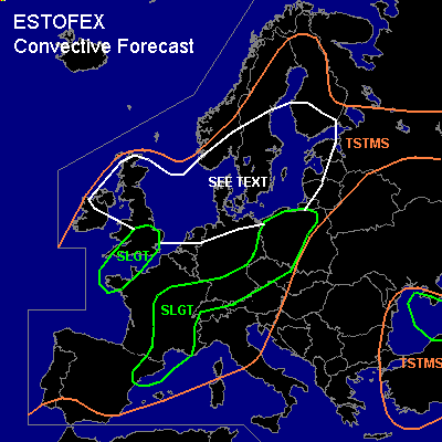
There is a slight risk of severe thunderstorms forecast across NErn Spain, SErn/Ctrl France, Wrn Switzerland
There is a slight risk of severe thunderstorms forecast across Srn UK, Bretagne
There is a slight risk of severe thunderstorms forecast across Nrn Poland, Czech Republic, Srn Germany
SYNOPSIS
A southwestern flow is in place over much of Western Europe, with a low pressure area west of the British Isles. A maximum of low level theta-e stretches from Spain towards Srn Finland. An upper trough near Spain is heading into France and is accompanied by upward motion. Along the theta-e ridge, CAPE is forecast by GFS to be generally in the 500-1500 J/kg range. As no significant BL convergence lines are found in model data, shortwave troughs embedded in the SWly upper flow are thought to be the main triggers.
DISCUSSION
...France, Switzerland, NErn Spain...
High end SLGT risk seems to be unfolding as fairly strong deep-layer shear (15-25 kts 0-6km), strong low level shear (>10 m/s 0-1 km) and moderate 0-3 km storm-relative helicities (~200 m²/s²) are forecast to be collocated with moderate CAPEs and moderate to strong forcing. These conditions are likely to support a few supercells and a MCS. The MCS may be accompanied by a bow echo/line echo wave pattern with widespread damaging winds. In that scenario an upgrade to MDT risk may be considered. Apart from severe gusts, large hail is likely, as well as a few tornadoes due to favorably low LCLs and strong low level shear - though low level buoyancy is forecast to be not particularly strong. GFS forecasts a lot of convective precipitation in eastern France and western Switzerland, supporting the MCS notion.
Note that the finer resolution models BOLAM and ARPS predict more CAPE farther westward than GFS (central France)
NErn Spain has less chance of tornadoes, because of lesser low level shear and helicities, but large hail and severe gusts (maybe microburst locally given strong delta-theta-e of >25 K due to midlevel dry air entrainment)
...Nrn Poland, Czech Republic, Srn Germany...
Deep-layer shear is moderate to strong over a large area, also here. In particular Poland, low level shear is enhanced, whereas low level buoyancy is also increased according to GFS (needs to be proven by soundings)... in this area slightly enhanced tornado probability. Otherwise, large hail and damaging winds can be expected, while storms may range from multicell clusters to MCS, with a few rotating updrafts possible where SREH is enhanced. GFS progs this parameter highest over SErn Germany, but can be enhanced anywhere by local topography.
...Srn UK, Bretagne...
Srn UK should expect a wave coming through after 18Z, with a theta-e maximum, low level convergence and midlevel UVMs, shear enhancements up to levels favorable for rotating updrafts. Apparently, buoyancy by GFS stays behind, though midlevel lapse rates are enhanced and GFS produces decent convective precip. Marginal threat of a tornado and marginally large hail seems to be present.
Shear is expected to increase dramatically over Bretagne by Wednesday morning. Deep layer shear is forecast to exceed 25 m/s, low level shear moderate at 7 m/s. Along with the forecast CAPE at/after the cold front, severe gusts as well as a few tornadoes/waterspouts are likely to occur.
...see text area (Srn Scandinavia, Nrn British Isles, North/Baltic Sea areas)...
Fairly quiescent kinematic conditions combined with several 100s J/kg of CAPE, moist profiles and steep low level lapse rates provide classic conditions for the development of waterspouts/landspouts. Especially showers on lines of sfc wind convergence should be watched, as they are usually the focus for spouts due to the stretching of the present vertical vorticity into updrafts. Many of the Mon 12Z/Tue 00Z soundings in the area seem to have potential to feature significant low level buoyancies (e.g. LI of -2 at 800 hPa), low LCLs and steep lower lapse rates. Spouts occasionally do damage.
#