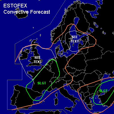

CONVECTIVE FORECAST
VALID 05Z MON 16/08 - 06Z TUE 17/08 2004
ISSUED: 16/08 00:13Z
FORECASTER: GROENEMEIJER
+ + + AMENDED + + +
There is a slight risk of severe thunderstorms forecast across western and northern Turkey, northeastern Greece, eastern Bulgaria, Black Sea
There is a slight risk of severe thunderstorms forecast across France, Switzerland, Western Germany, Benelux
General thunderstorms are forecast across much of western Europe, southern Scandinavia and the Baltic States and across much of Turkey, the southern and eastern Balkans and Greece
SYNOPSIS
Monday at 06Z... in the mid-troposphere a trough is expected over the eastern Atlantic and a ridge over the western Mediterranean Sea. In between a southwesterly flow is expected. Parallel to this flow... a waving frontal zone is present at the surface from northwestern Spain over western France to southern Scandinavia. Downstream... a trough over the Balkans is expected to evolve into a closed low. A strong zonal jet is located over Scandinavia.
DISCUSSION
...western and northern Turkey, northeastern Greece, eastern Bulgaria, Black Sea...
A shortwave trough over the Aegean Sea is expected to move slowly eastward. Ahead of the trough convection could be already ongoing on Mondat morning and more convection is expected to initiate during the day. As about 20 m/s of deep-layer (0-6 km) shear is expected over the area convective modes may include supercells and bow-echoes. These will be capable of producing large hail, damaging winds and perhaps a tornado or two.
...France, Switzerland, Western Germany, Benelux...
An MCS is expected to be ongoing over northern France
and/or the Benelux Countries. This MCS could produce a few strong wind events and perhaps some large hail as well. Also, it is not ruled out that a tornado forms as low-level shear is expected to be quite strong and LCL heights low. The MCS should gradually decay.
Another convective system or remnants thereof are expected over southern France. If the MCS persists into this forecast period, large hail and strong winds are possible threats of this activity.
Where less cloudiness is present solar heating is expected to allow around 500 - 1000 J/kg of 50hPa MLCAPE to form loacally. Scattered storms are expected to redevelop in the early afternoon. As about 20 m/s of deep-layer (0-6 km) shear is expected over the region, these will likely include supercells as well as multicell storms. The storms will likely produce isolated large hail. There is also a minor threat of strong to severe wind gusts. One or two tornadoes are possible as well since low level shear will likely be quite strong. The greatest likelihood of tornadoes is expected across southwestern Germany, Switzerland and east-central and northeastern France, where low-level shear is expected to be the strongest. A shortwave trough initially over the Atlantic is expected to move over the Iberian peninsula and be over SW France Tuesday morning. Ahead of it, rising motions are expected to induce the development of one or more larger convective systems over southwestern and south-central France on Monday evening and overnight.
...northeastern Spain...
An unstable, but generally quite strongly capped air-mass is present over the western Mediterranean sea. As some rising motions are expected over the area by various numerical models, it seems likely that a few updrafts will likely be able to break through the capping inversion most likely on Monday evening. About 2000 J/kg MLCAPE will likely be available. this in combination with 15-20 m/s of deep-layer shear will likely allow for the formation of a few supercells capable of producing large hail and strong winds. Tornadoes cannot be ruled out either. Although large-scale low level shear qill likely be quite low, sea breeze fronts and flow modifications by orography may help to create localised high SREH values that allow strong low-level mesocyclones to form that may spawn a tornado.
...UK, Ireland, western France...
An convecting unstable polar air-mass is expected to be present over the British Isles. Low LFC and LCL heights in this air mass will possibly allow for a few reports of funnel clouds, waterspouts and/or weak tornadoes. Small hail is also possible.
...Sweden, northern Baltic States, southwestern Finland...
Models are consistent in producing convective precipitation ahead of a trough approaching the area from the southwest. As around 15 m/s deep-layer (0-6) km shear is expected a few strong multicells should be possible that produce small and possibly some large hail as well as strong winds. The convection will likely gradually cluster into one or two MCS's that move northeastward over the Baltic Sea.
#