CONVECTIVE FORECAST
VALID 06Z THU 12/08 - 06Z FRI 13/08 2004
ISSUED: 11/08 20:56Z
FORECASTER: GATZEN
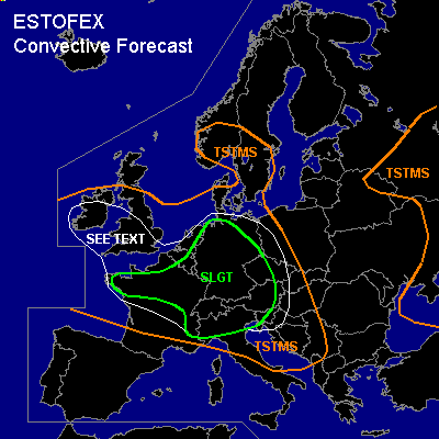
There is a slight risk of severe thunderstorms forecast across Northern France, southern Benelux, Germany, Alpine region, western Czech Republic, Austria, northern Italy
General thunderstorms are forecast across Southern and central Great Britain, France, northern Italy, Balkans, southern Scandinavia, western Russia, eastern Ukraina
SYNOPSIS
Weak short-wave ridge axis present from Tunisia to Austria and further to southern Scandinavia. Strong upper long-wave trough situated west of northern France/southern Great Britain. Several vort-maxima rotating around this trough will effect western and central Europe during the forecast period. At lower levels ... warm airmass is situated over northern Mediterranean and Alpine region, while moist maritime airmass has entered western Europe.
DISCUSSION
...Germany, Alpine region, western Czech Republic, western Poland, northern Austria
...
Southerly winds east of approaching cold front advects warm subtropical airmass into Germany and Poland during the day. This airmass is characterized by steep lapse rates below 750 hPa and poor lapse rates aloft as indicated by today's LFME Nimes sounding. On Thursday ... ahead of approaching cold front a surface low is forecast over the Alpine region, yielding easterly surface winds over Germany. Although low-level moisture will be limited ... low-level convergence over western Germany is forecast and GFS suggests CAPE up to 1000 J/kg due to insolation and moisture pooling. Over eastern France/Benelux ... convective initiation is expected in the morning hours along the cold front as upper vort-max should lead to UVM ... spreading westward into western Germany during the day. Expected deep (0-6km) vertical wind shear will be moderate with 15 m/s over NWrn Germany increasing to 25 m/s over western Alpine region. Low-level (0-1km) vertical wind shear should be quite weak initially. Thunderstorms that form may become supercells given rather strong 0-3km SRH values. Isolated large hail and severe wind gusts are forecast. One tornado or two are not ruled out. One or two MCS may evolve over western Germany during the day moving NW-ward. Severe wind gusts and isolated large hail associated with bow echoes/LEWPs should be the main threat over northern Germany. However ... rather weak instability is forecast and it is not clear if a MCS will form ATTM. Thunderstorms are expected over eastern Germany/western Poland during the night. Severe threat will be limited due to low-level stabilization. However ... if a MCS will form that moves eastward ... severe wind gusts and isolated large hail should be possible.
Over southern Germany/Alpine region and northern Austria ... instability is expected during the day. Low-level northerly winds and upslope flow are forecast ... and a few isolated thunderstorms are not ruled out ahead of approaching MCS/cold front. If thunderstorms will form ... locally strong low-level wind shear will be favorable for mesocyclones ... and large hail/damaging wind gusts will be possible. However ... current thinking is that weak upper forcing/Föhn over the Alps/ and weak instability will inhibit convective initiation during the day. Best chances are expected over Austria and the northern Alpine region/southern Bavaria. Later in the day ... strong forcing is forecast in the range of the short-wave trough and associated cold front. Thunderstorms should form over SWrn Germany where deep layer wind shear may be favorable for isolated mesocyclones capable of producing large hail and damaging wind gusts. A tornado is not ruled out. Thunderstorms should merge into a MCS/sqall line moving eastward. Severe wind gusts are expected along the cold front and associated MCS that should reach SErn Germany and northern Austria during the evening/night hours.
...Northern France, Benelux, western Alpine region, Wrn Germany
...
Rather strong vort-max is expected in the wake of the cold front. Backing surface winds are forecast and WAA/DCVA will lead to UVM. Upper cooling in the range of the trough and low-level WAA ahead of the vort-max should lead to sufficient instability to allow for thunderstorms. Latest model output suggests that low-level vertical wind shear will be adequate for mesocyclones. Convectively mixed low-level airmass and weak CIN/low-level CAPE are expected, and the chance for tornadoes should be significantly enhanced. A few tornadoes are expected if this scenario comes true, as well as one or two strong tornadoes. Isolated large hail and severe wind gusts are not ruled out. Thunderstorms should reach western Germany/Benelux during the evening/night. Weakening DCVA is forecast and overall risk of severe thunderstorms should decrease gradually.
...Northern Italy, southern Austria, northern Balkans
...
South of the Alps ... upper vort-max is expected to lead to sufficient UVM ... and thunderstorms should form in the afternoon/evening hours. Increasing deep vertical wind shear may lead to organized thunderstorms/mesocyclones. Isolated large hail and severe wind gusts are expected. There is also an enhanced chance for tornadoes. Convective activity should go on during the night hours and spread eastward.
...Great Britain
...
Underneath the upper trough ... convectively mixed maritime airmass may destabilize ... and thunderstorms are forecast. Weak vertical wind shear and low LCL height may be favorable for water spouts.
#