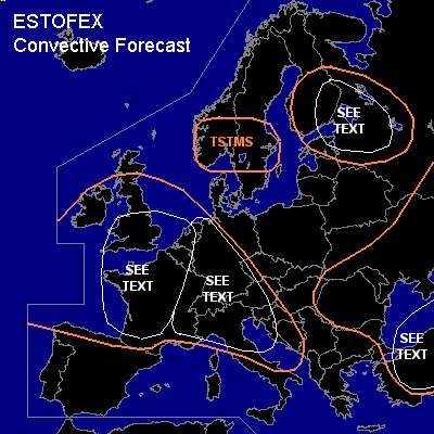
CONVECTIVE FORECAST
VALID 06Z WED 11/08 - 06Z THU 12/08 2004
ISSUED: 10/08 23:58Z
FORECASTER: GROENEMEIJER
General thunderstorms are forecast across much of west-central Europe, southern Scnadinavia, central Europe, northern Italy and the northwestern Balkans as well as the eastern Balkans, Turkey, the Ukraine and across Finland, and parts of northwestern Russia.
SYNOPSIS
Wednesday at 06Z... upstream of a ridge over central and south-central Europe, a closed mid/upper low is located about 600 km SW of Ireland and expected to move eastnortheastward. A shortwave trough on its southern flank is expected to reach western France by the end of the evening. Over eastern Europe, the main features are a NE-SW oriented longwave trough over the western Black Sea and the Aegean Sea, and a shortwave trough moving southeastward over Finland into Russia.
DISCUSSION
...northeastern Netherlands, Germany, Alps, Italy, Czech Republic...
A cold front is expected to be located from central Scotland to the northeastern Netherlands to southwestern Germany to southeastern France and the Balearics and reach a line from Denmark to the Czech republic on Thursday morning as it decays
somewhat, especially further south. Ahead of this front, a rather dry air-mass is inplace over much of Germany that will likely not allow for prefrontal convective activity. Isolated storms should however be possible near the frontal zone. These will likely not be severe given poor deep-layer shear profiles and low instability. More some storms are expected to occur over the western Alps as well as northern Italy. A few stronger storms are possible over the Po-Valley and the Adriatic. Low lapse rates, moderately strong wind shear and forcing for upward motion suggest that severe threat will remain quite limited.
...UK, Benelux, France...
In the wake of aformentioned cold front dropping mid-level temperatures and lingering moisture at low levels will probably allow for around 500 J/kg MLCAPE to form locally. Large-scale upward vertical motion is forecast to be quite limited until the evening. Nevertheless, some scattered storms will likely form. Over northwestern France, deep-layer shear on the order of 20 m/s is expected and slightly lower shear will likely be in place over the Benelux and southeastern England. In those areas, some storms could produce a few brief severe events including large hail and gusts and perhaps a weak tornado. Overall threat seem to be too small to warrant a categorical risk. Over the remainder of the UK, shear is lower implying an even lower severe threat.
During the evening hours the Atlantic trough is expected to approach and move into western France. Strong QG forcing for ascent, fairly strong deep-layer and low-level shear and nearly neutral profiles ahead of the system suggest that a rainband with embedded linear convection may form during the evening hours and overnight that moves into France. Strong and perhaps locally severe winds should be possible. It is not ruled out either that a tornado or two will form along the line.
...Turkey...
Ahead of the mid/upper level trough ascent and the presence of some latent instability will likely sustain convection over the Black Sea and new convection may form over the Turkish mainland. Latent instability should be rather low and deep-layer (0-6 km) shear around 10-15 m/s. This suggests a that the threat of severe weather will be low, although isolated large hail and strong winds may occur with more organised storm clusters.
...Finland, Russia...
A shortwave trough moves from central Finland southeastward into northwestern Russia during the forecast period. Numerical models suggest some latent instability will be present ahead of the trough, which in combination with rising motions suggest that convective activity can be expected. A strongly forced linear convective system seems to be the most like convective mode. A few strong winds will therefore be the main threat, although isolated -mostly small- hail cannot be ruled out either. the overall threat seems too low to issue a risk category.
#