CONVECTIVE FORECAST
VALID 06Z TUE 10/08 - 06Z WED 11/08 2004
ISSUED: 09/08 21:13Z
FORECASTER: HAKLANDER
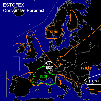
There is a slight risk of severe thunderstorms forecast across S/C/E-France, Corsica,NW-Italy, W-Switzerland
General thunderstorms are forecast across the UK, large parts of Scandinavia, NW-Spain, France, large parts of the Benelux countries, SW-Germany, much of C- and E-Europe, N- and C-Italy, and large parts of Turkey.
SYNOPSIS
A quasi-stationary Atlantic low SW of Ireland migrates E-ward very slowly as it zonalises. On the E-rn flank of this low, 500 hPa winds should decrease from 25-30 to about 15 m/s during the forecast period. At TUE/06Z, the frontal zone that is associated with the Atlantic low can be identified as an elongated area of enhanced cyclonic vorticity across Scotland, extending S-ward across England, NW-France towards N-Spain. During the forecast period, a stable short wave is expected to move from France towards the Netherlands. This causes the frontal zone to acquire a NW-SE tilt, and by WED/06Z, it is forecast across Scotland, extending SE-ward across the Netherlands and SW-Germany, then S-ward towards Corsica. During Tuesday afternoon and evening, a 25-28 m/s WSWly jet streak is forecast across the E-rn half of the Iberian Peninsula. East of an upper ridge across C-Europe, an upper trough should sweep E-ward across C/E parts of the Balkan and W-Turkey.
DISCUSSION
...SLGT region...
Latent instability, vertical wind shear, and QG forcing beneath the left-exit region of the aforementioned jet streak should combine into a set-up that supports a few severe convective events.
MLCAPE should reach 500-1000 J/kg across much of the area, and with 0-6 km AGL shear (DLS) of about 20 m/s, storms could become organized, despite the low MLCAPE.
GFS forecasts about 100 m²/s² 0-3 km AGL SREH.
However, across the mountainous terrain, low-level flow is strongly modified, which affects both SREH and DLS. Since MLCAPE and DLS support organized storms, we cannot rule out that some storms will become supercellular, producing large hail and severe wind gusts. Since LCLs should be low, we cannot rule out a tornado either. We expect moderate to high storm coverage, because of the strong QG forcing and significant QPFs according to various models. Storms could cluster into one or more MCSs.
...SW-Germany...
According to some models, an MCS should form ahead of a short-wave trough across E-France, moving into SW-Germany in the evening and night. If this scenario materializes, one or two (marginally) severe convective wind events are possible across the SEE TEXT region.
...N-Turkey, S-rn Black Sea...
Daytime heating should locally result in 500-1000 J/kg MLCAPE. With moderate DLS of 20-25 m/s and about 150 m²/s² SREH, strong storms could form, including some supercells. Severe wind gusts, large hail, and an isolated tornado are possible with any supercell that forms. There is uncertainty with respect to the amount of overlap of stronger DLS towards the south and increased MLCAPE towards the north. Because QPFs do not show a strong signal until late evening, when MLCAPE should be less, we refrain from issuing a SLGT at this time. An upgrade might be necessary for this area.
#