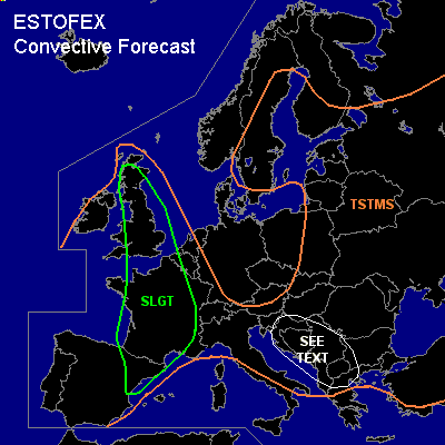

CONVECTIVE FORECAST
VALID 06Z MON 09/08 - 06Z TUE 10/08 2004
ISSUED: 09/08 01:11Z
FORECASTER: GROENEMEIJER
There is a slight risk of severe thunderstorms forecast across parts of Great Britain, Belgium, France and Spain
General thunderstorms are forecast across much of western Europe, much of Eastern Europe and the northern Mediterranean Sea region as well as the central and northern Balkans and much of Turkey.
SYNOPSIS
Monday at 06Z... a mid/upper low pressure area is located west of the British Isles, accompanied by a gradually filling surface low. An area of high pressure is located over Scandinavia. Another low at mid/upper levels is almost stationary over the northwestern Ukraine. A shortwave trough over the Czech Republic is moving southward reaching central Croatia on Tuesday morning.
DISCUSSION
...British Isles...
At 06 Z, the cold front of the Atlantic low is expected from western Great-Britain to near Bordeaux to southwestern Spain. A mid/upper shortwave trough is expected over the English Channel. Rather strong forcing for upward motion ahead of this system and the availablity of a few 100's of J/kg CAPE over Great Britain suggest that widespread convection will take place ahead of the trough. Convection will likely be organised in lines along and ahead of the cold front as it moves slowly northeastward. Near the front, about 15 - 25 m/s deep-layer (0-6 km) shear be present. This may allow a few embedded rotating updrafts to form. Given that rather strong low-level (15-25 m/s @ 850 hPa) winds are forecast ahead of the trough, storms have a potential of producing strong and severe winds. The LCL height is expected to be rather high at first, but where it becomes lower, some tornado threat will exist given the strong low-level shear. A few events of large hail are possible too, especially with any rotating updraft that forms.
...France...
The amount of instability that forms over France on Monday will be highly dependent on the cloud cover. Where clouds dominate a few 100's of J/kg MLCAPE are expected but in larger clearings more than 1000 J/kg MLCAPE should be able to form. Scattered storms are forecast to persist and form during the forecast period both along and ahead of the cold front that moves slowly eastward. These will likely cluster into convective systems. Under a southsouthwesterly jet that is located over western France, deep-layer shear is strong, (20-25 m/s 0-6 km). This should be more than adequate for the formation of a few supercells. Their main threats are expected to be large hail and strong winds. After sunset, convective systems are expected to move north to northnortheastward over France while their severe threat gradually diminishes.
...Spain...
Scattered storms are expected to form over northeastern and eastern areas as some large-scale rising motions overspread the region. About 1500 J/kg MLCAPE should be present near the coast. This and deep-layer (0-6 km) shear being around 20 m/s indicate some supercells will likely form. Their main threats are expected to be large hail and strong winds.
...western Balkans...
A few 100's of J/kg CAPE, rather strong, 15-20 m/s, deep-layer (0-6 km) shear and some upward vertical motions create the possibily of a few quite strong storm clusters to move southeastward over the area. A few strong winds and mainly small hail are expected, although it is not ruled out that severe levels be exceeded in some places.
#