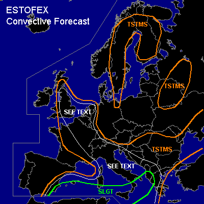

CONVECTIVE FORECAST
VALID 06Z THU 05/08 - 06Z FRI 06/08 2004
ISSUED: 04/08 18:58Z
FORECASTER: GATZEN
There is a slight risk of severe thunderstorms forecast across southwestern and south-central Mediterranean
General thunderstorms are forecast across western and central Mediterrenean, France, eastern Great Britain, Benelux, extremely western Germany, Alpine region, Balkans, northern Black Sea, extremely northeastern Germany, Sweden, Finland, Belarus, and western Russia
SYNOPSIS
Weak upper ridge is present over Europe east of an intense long-wave trough over the northern Atlantic. Delta of northern Atlantic jet stream is situated west of the continent yielding a relatively strong southern branch that evades into the Mediterranean. Embedded short-wave trough has reached the Iberian Peninsula a propagates eastward into western Mediterranean. Over eastern Europe ... weak upper cut-off low will remain.
DISCUSSION
...Western and central Mediterranean...
Focus of expected convective activity will be the short-wave trough over the western Mediterranean. This trough is forecast to move eastward and tilts negatively at the southeastern flank of the Atlantic long-wave trough. It is expected to merge with the eastern European cut-off later on. At the southern flank of this short-wave trough ... relatively strong upper jet streak (up to 40 m/s at the 300 hPa level) evades into the central Mediterranean reaching Greece on Thursday evening. At the cyclonic flank of this jet streak ... latest model output suggests strong DCVA over parts of the Mediterranean. At lower levels ... steep lapse rates up to the 600 hPa level have spread over the central and southern Mediterranean. Underneath low-level inversions, substantial moisture has build locally, yielding CAPE in the order of 1500 J/kg as indicated by Wednesday's soundings.
Over the western and central Mediterranean, thunderstorms have already formed over land due to differential heating and orographic enhanced low-level lift. On Thursday ... some clouds of today's convection may inhibit insolation locally, but strong surface heating should be possible over the land masses of the Mediterranean. Mentioned jet streak indicated on latest water vapor images will affect the region where QG forcing is expected ... and rather early initiation will likely occur over widespread areas initially over land. At the northern flank of the jet streak ... deep layer wind shear is forecast to be rather weak as indicated by GFS model output. However ... it is not ruled out that locally up to 20 m/s 0-6km vertical wind shear will be possible. Given large CAPE values up to 2000 J/kg ... a couple of supercells should form over the western and central Mediterranean. Very large hail, strong wind gusts and a tornado or two are expected with this convection.
To the south ... decreasing low-level moisture and QG forcing should limit thunderstorm potential. To the north ... decreasing vertical wind shear in forecast. However ... given widespread convective activity and large CAPE values, isolated supercells are expected capable of producing large hail and strong wind gusts. Weak low-level wind shear limits the tornado potential with these storms. During the day ... thunderstorms may merge into one or two MCS moving ENE-ward reaching northern Greece/southern Balkans later on. Strong wind gusts and large hail will be likely with any MCS that forms.
...Eastern France, western Germany, Benelux, eastern Great Britain...
At the northeastern flank of the western Mediterranean short-wave trough ... WAA is expected from the Alpine region to eastern France, western Germany, Benelux, and eastern Great Britain. However ... QG forcing should remain low as mentioned short-wave trough cuts off over France and merges with the eastern European cut-off. Strongest UVM is forecast over Great Britain where a short-wave trough will remain ... moving northeastward. Affected airmass is characterized by mid-level steep lapse rates between 850 and 750 hPa as indicated by latest ETGI Idar-Oberstein sounding, and CAPE values up to 1000 J/kg are forecast. On Thursday ... stratiform clouds of today's convection should limit insolation over parts of France, Benelux, and Germany. If insolation will lead to sufficient instability ... thunderstorms should rebuild over France. Weak synoptic forcing should inhibit widespread convection especially over Germany and Benelux. To the north ... easterly surface winds are forecast and low-level convergence/upslope flow especially over Great Britain may lead to sufficient low-level forcing/low-level wind shear to support isolated organized convection. If supercells will form ... large hail and strong wind gusts should be the main threat. However ... isolated tornadoes are not ruled out though.
#