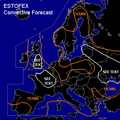

CONVECTIVE FORECAST
VALID 06Z TUE 03/08 - 06Z WED 04/08 2004
ISSUED: 02/08 20:53Z
FORECASTER: HAKLANDER
General thunderstorms are forecast across the UK, large parts of the Iberian Peninsula, the Balearic Islands, France, Belgium, Luxemburg, S-Netherlands, parts of Germany, Switzerland, Austria, the Czech Republic, N- and S-Poland, S-Norway, much of Sweden and Finland, the Baltic States, Belarus, Ukraine, the Italian Peninsula, and much of the Balkan Peninsula.
SYNOPSIS
An ESE/WNW oriented trough across E-Europe with its axis initially across Poland and Moldova is expected to slowly migrate Wward. On the Atlantic, an extended ULL remains SW of Iceland. On its Ern flank, a weak upper ridge across Wrn parts of the European continent connects an upper high across NW-Russia to another high across NW-Africa. Across the entire TSTMS area, 0-6 km AGL shear should generally be (much) less than 15 m/s.
DISCUSSION
...S-Ukraine, Moldova, E-Romania...
A short-wave disturbance, embedded in the ESEly flow on the NErn flank of the aforementioned trough, should cross the area during Tuesday evening and into Wednesday night. Mostly DCVA-related UVV in a moderate CAPE enviroment with little CIN is expected to result in an MCS, later on in the forecast period. Especially with 0-1 km shear increasing to > 10 m/s, clustered storms are expected to persist as they become elevated. Large hail and a few strong wind gusts are possible, but these events should be local. Because 850 hPa winds should be less than 15 m/s, downward momentum transport should remain limited and with quite moist mid levels, the risk for severe wind gusts seems too small to warrant a SLGT.
...Estonia, Belarus, parts of Ukraine...
Very little vertical wind shear and moist air through a deep layer should inhibit turbulent transfer of heat, moisture and vorticity within updrafts. Forecast soundings show relatively high upward accelerations in the lowest few km, which enhances stretching of existing vertical vorticity in the boundary layer. Additionally, large-scale convergence is expected at low levels, enhancing the threat for a few brief tornadoes during the day.
...N-/E-France...
MLCAPE could locally reach 2000 J/kg during late afternoon. Despite poor vertical wind shear, there is a threat of large hail and severe wind gusts, especially due to the combination of high CAPE and relatively dry air at mid levels. One or two short-lived tornadoes could occur, since moderate CAPE and low LCLs are forecast in a low-shear environment. Considering the poor kinematic set-up, severe convective events should be brief and local. We therefore refrain from issuing a SLGT.
...S-Britain...
Although less CAPE is forecast than across France, conditions similar to those across the French SEE TEXT area and significant low-level convergence could result in one or two brief tornadoes.
#