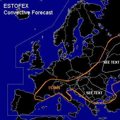

CONVECTIVE FORECAST
VALID 06Z FRI 30/07 - 06Z SAT 31/07 2004
ISSUED: 29/07 20:24Z
FORECASTER: GATZEN
General thunderstorms are forecast across NWrn Spain, Srn France, Alpine region, central Italy, SErn and Ern Europe
SYNOPSIS
Broad upper ridge present over Europe. Embedded cut-off lows are forecast over the southern North Sea, the Baltic States, the northern Balkans and extremely southern Mediterranean on Friday. At lower levels ... warm airmass will be present south of a line from northwestern France to northern Germany, southern Poland and further to extremely southeastern Scandinavia. Rather cold airmass will remain over the northern Balkans.
DISCUSSION
...Southeastern Europe...
In the range of the upper cut-off low over southeastern Europe ... convectively mixed airmass is present as indicated by latest Budapest sounding. This airmass will remain over the northern Balkans and should destabilize during the day. CAPE in the order of several hundred J/kg will be likely, and weak cap should not inhibit convection. Moderate low (0-1km) and deep (0-6km) vertical wind shear is expected north of the cut-off low over southern Poland, Slovakia, western Ukraine, northern Romania and Bulgaria ... and 0-1km SRH should reach up to 100 J/kg, enhancing the potential for rotating updrafts. Supercells are forecast capable of producing large hail, damaging wind gusts and a tornado or two. Overall threat seems to be too marginal to warrant a SLGT RISK ATTM. However ... an upgrade may be needed if instability/shear will be greater than forecast.
From Macedonia and northern Greece to southern Bulgaria and northwestern Turkey ... instable airmass is expected as latest Istanbul sounding shows rich low-level moisture and large CAPE due to steep mid-level lapse rates. On Friday ... cold front southeast of the cut-off will reach Bulgaria, where thunderstorms are expected. Moderate vertical wind shear is forecast and some thunderstorms may organize. Supercells are not ruled out, and large hail, damaging wind gusts and a tornado or two are not ruled out. Activity should spread eastward into Turkey during the evening ... and isolated thunderstorms may be severe with a chance of large hail, damaging wind gusts and probably a tornado or two. If synoptic forcing will become stronger than expected ... and widespread thunderstorms may form ... and upgrade to SLGT should be warrant.
...E Europe ... W Russia...
Friday's situation seems to be similar to Thursday. Thursday's soundings revealed maximum MLCAPEs of about 1500 J/kg over E Europe and W Russia. On Friday ... instable airmass should remain east of the cut-off low over northern Balkans. Shear within this air mass is expected to remain fairly weak.
Nonetheless ... the strong thermodynamic profiles may support an isolated severe TSTM event or two ... mainly tied to local augmentations of low-level SRH by outflow boundaries ... orography etc. But allover severe threat should be quite limited ... will place a SEE TEXT area where CAPEs are expected to be highest.
#