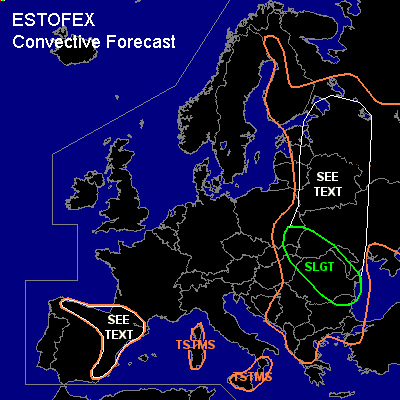

CONVECTIVE FORECAST
VALID 06Z WED 28/07 - 06Z THU 29/07 2004
ISSUED: 27/07 22:18Z
FORECASTER: GROENEMEIJER
There is a slight risk of severe thunderstorms forecast across parts of Poland, the Ukraine, Moldova, Romania, Hungary and the Slovak republic
General thunderstorms are forecast across much of eastern Europe and a part of eastern Scandinavia, northern and eastern Spain, extreme southern France, over Sardinia and Sicily and southern Italy
SYNOPSIS
Wednesday at 06Z... a ridge is building over western Europe. A closed mid/upper low pressure area is almost stationary over the northwestern Balkans. A jet streak over the Adriatic is rotating around the low, its exit region reaching the eastern Balkans on Thursday morning. A shortwave trough off the coast of Iberia is moving eastward, reaching eastern Iberia on Thursday morning.
DISCUSSION
...slight risk area...
Thunderstorms are expected to be ongoing near the mid/upper low pressure system on Wednesday morning. Solar heating will help destabilise the air mass to its north and east. Current thinking is that about 1000 - 1500 J/kg MLCAPE should be able to form. In the left exit region of the aformentioned jet streak widespread convective development is expected. Although wind shear is not expected to be particularly strong, strong forcing for upward motion will promote the formation of one or two MCS's that should be capable of producing strong and severe wind gusts. A minor threat of large hail will exist as well, both with isolated storms as with larger convective systems that will likely form.
...
extreme eastern Poland, western ukraine, Belarus, eastern baltic States,
part of western Russia....
1000 - 2000 J/kg of uncapped CAPE is expected to form in the indicated area. Although deep-wind shear is forecast to be low across the area, any storm in the area can produce isolated severe weather, most likely large hail and strong winds. the overall risk seems to be somewhat too marginal to issue a risk category.
...northern and eastern Spain, extreme southern France...
A shortwave trough that moves into the Iberian peninsula will likely cause rising motions ahead of it. It is expected that mid-level lapse rates steepen and some convergence will occur at the surface. This will aid a few isolated storms to form, that may bring localised severe weather including some large hail and strong to severe winds. Storm coverage is expected to remain low or very low, so that a risk category is not necessary.
#