CONVECTIVE FORECAST
VALID 06Z TUE 27/07 - 06Z WED 28/07 2004
ISSUED: 26/07 22:32Z
FORECASTER: HAKLANDER
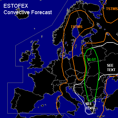
There is a slight risk of severe thunderstorms forecast across FYR-Macedonia, parts of FYR-Serbia, W-Hungary, much of Romania, W-Ukraine, W-Belarus, E-Poland, E-Lithuania.
General thunderstorms are forecast across Sweden, much of Finland, E-Germany, W- and E-Poland, the Czech Republic, parts of Austria, much of Italy, Corsica, the Tyrrhenean Sea, the Adriatic Sea, the Balkan Peninsula, the Aegean Sea, Moldova, Ukraine, Belarus, Estonia, Lithuania, parts of the Russian Federation.
SYNOPSIS
At TUE/06Z, a long-wave trough at mid levels should extend SSEward from the Norwegian Sea across the Czech Republic and the Adriatic Sea towards the Ionean Sea. This trough should slowly migrate Eward as it cuts off an ULL, which is expected near Croatia at WED/06Z. East of the upper trough, a large zone with weak QG ascent is forecast at 700 hPa, but with a few baroclinic waves of enhanced forcing.
DISCUSSION
...SLGT area...
Monday's 12Z soundings already indicated that moderate to high MLCAPE is present S and E of the aforementioned trough. Similar amounts of MLCAPE are expected to rebuild on Tuesday. Furthermore, a baroclinic wave should migrate Nward across W-Ukraine, W-Belarus and the Baltic States. In its warm sector, where strong QG forcing is forecast, 1000-1500 J/kg MLCAPE should be able to form and with 15-20 m/s deep-layer shear, multicells could become well-organised and severe. Severe wind gusts and large hail are possible with these storms. Especially across the northern half of the SLGT area, 0-3 km SREH values of 100-200 m²/s² seem favorable for some supercells. Considering LCLs below 1000 m AGL combined with about 10 m/s 0-1 km AGL shear, tornado threat within supercells should be enhanced.
Further south, MLCAPE should be somewhat less, but another embedded short wave could provide more than 10 m/s 0-1 km AGL shear and strong upward forcing, which could yield local destabilisation and enhanced multicell organisation. With less deep-layer shear than further north, the main convective mode seems to be multicells, possibly containing bowing segments. Thunderstorms are expected to cluster into one or two MCSs and apart from a risk of severe wind gusts, torrential rainfall may cause floodings.
...Ukraine, E-Belarus...
With very little wind shear and negligible QG forcing, multicells seem likely, which could cause a few local and brief severe weather events. With 1500-2000 J/kg MUCAPE across a significant area, a few large hail and severe wind events cannot be ruled out. It seems that one or two weak (non-supercell) tornadoes cannot be ruled out either, given moderate to high CAPE, low LCLs and very little wind shear. Severe weather risk seems too small to warrant a SLGT because of the poor vertical wind shear, but an upgrade may be needed for this area later on.
...Croatia, Bosnia-Herzegovina, FRY-Serbia, FRY-Montenegro, Albania, Kosovo...
Low CAPE but about 20 m/s deep-layer shear and strong upward forcing due to DVCA ahead of the approaching ULL could result in (partially elevated) multicells, with the possibility of severe wind gusts. It is still uncertain if and how much MLCAPE will manage to build, so the situation seems too conditional to warrant a SLGT at this time.
#