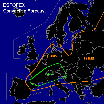

CONVECTIVE FORECAST
VALID 06Z FRI 23/07 - 06Z SAT 24/07 2004
ISSUED: 22/07 19:42Z
FORECASTER: GATZEN
There is a slight risk of severe thunderstorms forecast across southern Central Europe
General thunderstorms are forecast across Central Europe, northern Mediterranean, eastern Europe
SYNOPSIS
Intense long-wave trough over the Atlantic yields a strong southwesterly flow over western and central Europe. During the forecast period ... the southern part of this trough will cut off, and model forecasts indicate large-scale rising geopotential. Over Europe ... upper flow will turn west- to northwestward and CAA is expected to the northwest of a line from central Iberian Peninsula to Alpine region to Baltic Sea.
DISCUSSION
...Southern Central Europe...
Fridays convective activity is uncertain ATTM ... as development during Thursday/Friday night will create the convective setup in the range of the warm airmass. Current indications are that outflow boundaries of overnights MCSs may be favorable for early initiation over central France, Benelux and western, central and southern Germany as well as the western Alpine region. Strong jet streak/upper vort max is expected to move into central France during the day, and UVM is expected spreading eastward reaching the Alps in the evening. Strong deep layer wind shear over France should be sufficient for rotating updrafts. However ... models suggest CAA east of expanding high over the Atlantic ... and UVM/CAPE should decrease during the day over central France and western/southern Germany. If supercells will develop ... isolated large hail, damaging wind gusts and a tornado or two are expected. To the east ... cold front should move into eastern Germany, Czech Republic, and Austria. Thunderstorms are expected. Rather weak vertical wind shear will be present ... and thunderstorms should be non-severe. However ... strong wind gusts are not ruled out.
#