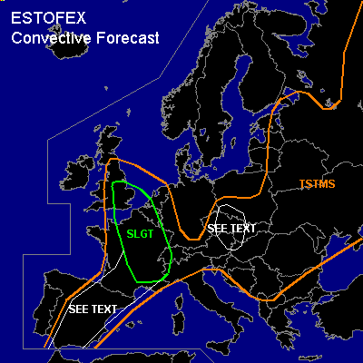

CONVECTIVE FORECAST - UPDATE
VALID 12Z THU 22/07 - 06Z FRI 23/07 2004
ISSUED: 22/07 12:07Z
FORECASTER: GATZEN
There is a slight risk of severe thunderstorms forecast across Northern and central France, Benelux, southern Great Britain
General thunderstorms are forecast across Iberian Peninsula, western Czech Republic, Austria, northern Balkans, western Germany, Alpine region, Balkans, Baltic States, eastern Poland, western Belarus, western and eastern Ukraina, western Russia
SYNOPSIS
Upper high geopotential axis is present from Algeria to eastern Alpine region and further to northern Russia ... and broad SW-erly upper flow remains to the west of this ridge axis. Over SE-ern Europe ... upper low-pressure system is centered over SW-ern Russia. During the forecast period ... a short-wave trough will cross Central Europe eastward. Two additional vort-maxima will cross Great Britain and N-ern France. At lower levels ... warm and unstable airmass remains SE of a line from central Iberian Peninsula to the Channel to northern Germany and further to the Baltic States.
DISCUSSION
...Northern France, Benelux, southern Great Britain
...
Strong southwesterly flow present over western Europe ... and embedded short-wave trough/vort-max will cross northern France/Benelux and southern Great Britain during the next hours. Downstream of this feature ... plume of warm airmass is advected northward ... with a Theta-E axis reaching from central France to southeastern Great Britain in the evening. Large CAPE is not expected as steep mid-level lapse rates will remain over southern and central France, where more than 2000 J/kg may be possible. However ... strong UVM due to strong WAA is forecast ... and thunderstorm initiation is expected in the range of a weak surface low over southern central England, where easterly surface winds are forecast ... and upslope flow/low-level convergence is likely. Thunderstorms that form should encounter boundary layer airmass as low-level air should be rather moist and warm with temperatures in the range of 24°C, allowing for CAPE up to several hundred J/kg. Developing thunderstorms may organize due to rather strong (20 m/s+) deep layer wind shear and increasing low-level wind shear due to forecast easterly surface winds over southern Great Britain, northern France and Benelux. Supercells are possible capable of producing large hail and damaging wind gusts. There is also an enhanced chance of tornadoes. Thunderstorms should merge into a MCS that is expected to reach southern Great Britain and Benelux. Heavy precipitation, severe wind gusts and isolated large hail are expected. Tornadoes are not ruled out.
For the southeastern part of the SLGT RISK area see previous outlook.
...Czech Republic, southwestern Poland, eastern Austria
...
Very warm/moist airmass is present east of approaching convergence line. During the next hours ... thunderstorms are expected in the range of this convergence line. Isolated large CAPE is forecast ... and thunderstorms may become supercellular, capable of producing isolated large hail, damaging wind gusts and a tornado or two. Greatest activity is expected over northern Czech Republic, where thunderstorms may merge into a MCS later on. As vertical wind shear should remain quite low ... chance for severe weather will be limited ... and a SLGT seems to be not warrant ATTM.
...Other areas...
See previous outlook.
#